Pioneering Flood Risk Management in the Atlantic

| |

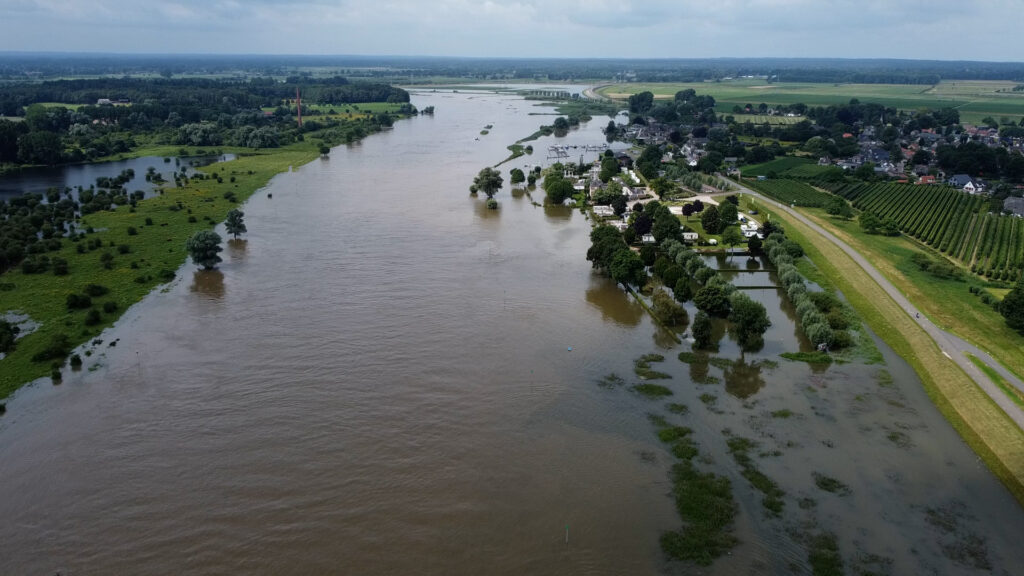
After setting the scene on IMPETUS work in the Netherlands last year,  with the help of Martine Rottink, a consultant at Nelen & Schuurmans, we share some more light on the activities in the IMPETUS Atlantic Demosite. With climate change on the rise, the IMPETUS project is set to introduce a cutting-edge decision support tool designed to reshape spatial planning and fortify communities against the looming threat of floods.

The Atlantic demosite

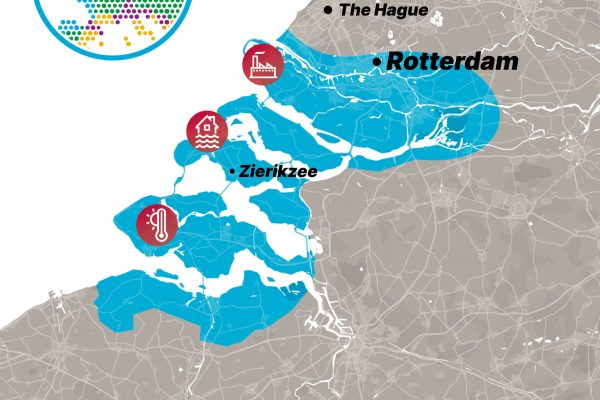
Within the IMPETUS project, partners working in the Atlantic demosite are looking to create digital support tools for climate change mitigation and adaptation related to different climate risks. The adaptation efforts are focused on heat stress and flooding risks, where the mitigation efforts of the projects are directed to stimulation of the decarbonization of chemical clusters within the Port of Rotterdam. For each of the topics in the Atlantic demosite, the project partners are working on the development of new and innovative tools and technology, that are meant to accelerate the implementation of both mitigation and adaptation measures.

Navigating Risk through innovative visualization and collaboration networks

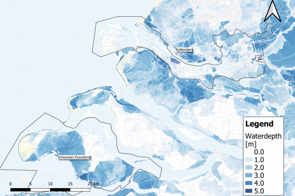
Flood risk management is more than just predicting the likelihood of a flood event. Risk, in the IMPETUS project framework, is a product of consequence and probability. The project considers not only the potential occurrence of floods but also factors in consequences such as casualties and economic damages.

While flood maps covering the entire country exist, translating this wealth of data into practical spatial planning measures has proven challenging. For this reason, IMPETUS partners have been involving diverse stakeholders, particularly municipal decision-makers responsible for spatial planning, to help design their solutions. Workshops and collaborative discussions form a crucial part of shaping the decision support tool to ensure it meets the real-world needs of those on the front lines.

From the different stakeholder sessions, it became apparent that a better visualization of flood simulations might help the implementation of flood adaptation measures. Currently, flood simulations are visualized in 2D maps. However, visualizing these flood simulations in 3D, projected in a 3D digital environment, would help both policy-makers and the broader public in general to grasp the impact of potential flood events and therefore stimulate the acceleration of flood measures.

Simulating tomorrow – a tool-in-progress

The IMPETUS decision support tool is no static concept; it’s an evolving online application that can be tailored to the needs of specific municipalities. Its capabilities? Offering critical insights into flood risks, potential consequences, and actionable measures for new developments. The development process is iterative, with ongoing input from stakeholders.
One of the main goals within the Atlantic demosite is to develop a tool that can be used by municipalities everywhere in the Netherlands to obtain more insight into the flood risks in their area. By incorporating flood risks very early on in spatial development processes, future flood risks can be decreased or even avoided. The tool can play an essential role in these processes.

Fostering a culture of Innovation

The IMPETUS project is not just about data and simulations; it’s about fostering a culture of innovation. Rottink highlights a local example—floating houses in Utrecht—that showcases how innovative construction methods can align with spatial planning, considering the imminent threat of floods.

Work in the Atlantic Demosite is steering the Netherlands toward a future where flood risk management is not just a reactive measure but an integral part of urban planning. By amalgamating scientific insights, stakeholder input, and an interactive decision support tool, Impetus seeks to fortify communities and infrastructure, paving the way for resilient and sustainable urban development in the face of evolving climate challenges.

Watch the interview with Martine Rottik below:

icon_heat

High temperatures

Record-breaking summertime temperatures have been recorded in the Netherlands in recent years. With global temperatures rising, such extreme weather events will occur more often, and for longer periods. Prolonged high temperatures, with warm nights as well as hot days, can cause heat stress* and related health issues, particularly among city populations.

*Heat stress occurs when the human body cannot get rid of excess heat and can impact wellbeing through conditions such as heat stroke, exhaustion, cramps and rashes.

"We want to enable municipality decision makers who are working on spatial developments to identify heat stress 'hot spots' and cool areas, analyse the future effects of climate change, and model the effect of different heat stress-reducing measures. The tool must provide them with an easy starting point to integrate heat stress risks in their projects."

Issue

Despite the cooling effect of the sea in the region of Zeeland, the growing risk of heat stress has become a concern.

Elderly and other vulnerable people are more impacted by the effects of prolonged heat, which can cause headaches, dizziness, insomnia and other health issues – even death. Excess temperatures also affect general comfort and liveability of cities. Water quality can be reduced, both for drinking and swimming, and infrastructure can be affected. Buildings and concrete surfaces trap heat, potentially leading to damage, and release it during the night, keeping temperatures warm.

During heat waves, it is important that everyone has access to a cool and comfortable place. Appropriate spatial planning can help to decrease and deal with heat stress. Environmental factors like water bodies, trees, and shade have a major impact on stress caused by high temperatures. Therefore, planting trees, removing concrete surfaces, creating green roofs and cool spaces can improve our comfort and health. The IMPETUS Atlantic team is developing a digital tool to support regional decision making for city planning to address these needs.

icon_flood

Flood risk

By 2050, sea-level within this region is predicted to rise by 15-40 cm, with more frequent extreme weather and more (severe) storms triggered by climate change. These changes will exacerbate the natural risk of flooding in the IMPETUS ‘Atlantic’ region, because it is surrounded by rivers and the sea, and is below sea level.

*Risk takes into account two aspects; the chance that an event will occur and the negative impact of such an event once it occurs. When there is a low chance that an event will occur, but its impacts are huge, the risk is still significant.

“In the Netherlands, an extensive system of dikes protects us against sea and river flooding. We have always put our faith in this defence and focused almost solely on flood prevention. However, pressure on our system will increase with climate change and rising sea levels. To adapt and maintain a safe living environment, we should develop other safety measures, like more robust spatial planning and contingency plans."

Issue

Rotterdam city, is located in Rijnmond – ‘mouth of the Rhine’. The Rhine river flows through this densely populated area and characterises the region. Protections such as sea dikes and storm surge barriers have been constructed to protect the region, but flooding still occurs.

People living in the city are accustomed to seeing smaller floods. The changing climate affects the interplay between rainfall, river levels and sea storms, increasing the flooding risk. Water levels could rise by a few metres, even in populated areas, with potentially massive impacts. 

Mitigation measures such as storm surge barriers reduce the chance that high water reaches the city, but to minimise the impact of floods when they do occur, adaptation strategies are also needed. A city that can adapt to be safe from floods must be carefully designed. How best to design such an adaptive city?

Critical infrastructure, such as hospitals and evacuation routes, must be accessible at all times. Planning how to best protect them, homes and lives is complex. Flood water behaves in a complex way and flood risks show strong spatial variations. The IMPETUS Atlantic team is developing a digital tool to support regional decision making for adaptive city planning. 

icon_factory

Energy and waste water

To become climate-neutral by 2050, climate mitigation* efforts are crucial in our strategy for how to deal with climate change. Reducing our energy consumption is a significant mitigation step. In the Netherlands, 15% of energy is consumed in the Rijnmond area around the port of Rotterdam, in large part by a major petrochemical industry cluster.

*Climate mitigation encompasses measures such as technologies, processes, or practices that reduce carbon emissions or enhance the sinks of greenhouse gases.

Issue

The Rotterdam port petrochemical industry cluster is Europe’s largest. It consumes 70% of the Rijnmond region’s energy. A large part of this energy is wasted (64%, 203 petajoules). More than half of that energy is lost with wastewater. In addition, most energy processes within these industries rely on fossil fuels, which has a significant impact on the climate.

Energy use must be minimised and fossil fuels should be replaced by renewable sources if climate change is to be mitigated. Electrification of processes opens up the possibility to use more renewable energy and can greatly impact decarbonisation. Recovering wasted heat would significantly reduce energy consumption and is a first step towards a more circular industry. 

Supporting industries in a transition towards climate-neutrality depends on identifying how best to reduce their carbon footprint without sacrificing production or performance. The IMPETUS Atlantic team is creating a digital tool that supports decision making about pathways towards an effective energy transition for EU industry.