Situation:
The metropolitan Berlin-Brandenburg region in the north-eastern German lowlands has a relatively high surface area of rivers and lakes, but natural flow is low and precipitation is decreasing.
The city of Berlin and its metropolitan region rely on groundwater as the drinking water production source. Treated wastewater is currently released back into the local freshwaters, resulting in a partially closed water management cycle within the city area. Brandenburg state has a higher reliance on water for agriculture and ecosystems. The rising pressure of climate change is impacting the natural water cycle.
PROGNOSIS
Contact this team | Kontaktieren Sie dieses Team :
- Daniel Wicke – daniel.wicke[@]kompetenz-wasser.de
Issues:
Water stress
- Affects health, urban and peri-urban development, climate change mitigation efforts.
- Deterioration of water production for drinking and agriculture.
- Increasing need for irrigation and agricultural re-use of treated waste water.
Water usage conflicts
- Potential usage restrictions could impact drinking water production.
- Exacerbation of existing conflicts by transition to climate-neutral energy production and development of new industries.
New policies required
- For adequate management of different interests.
- To harmonise the approach across the federal states of Berlin and Brandenburg.
- To converge single-aspect policies into an integrated, common strategy.
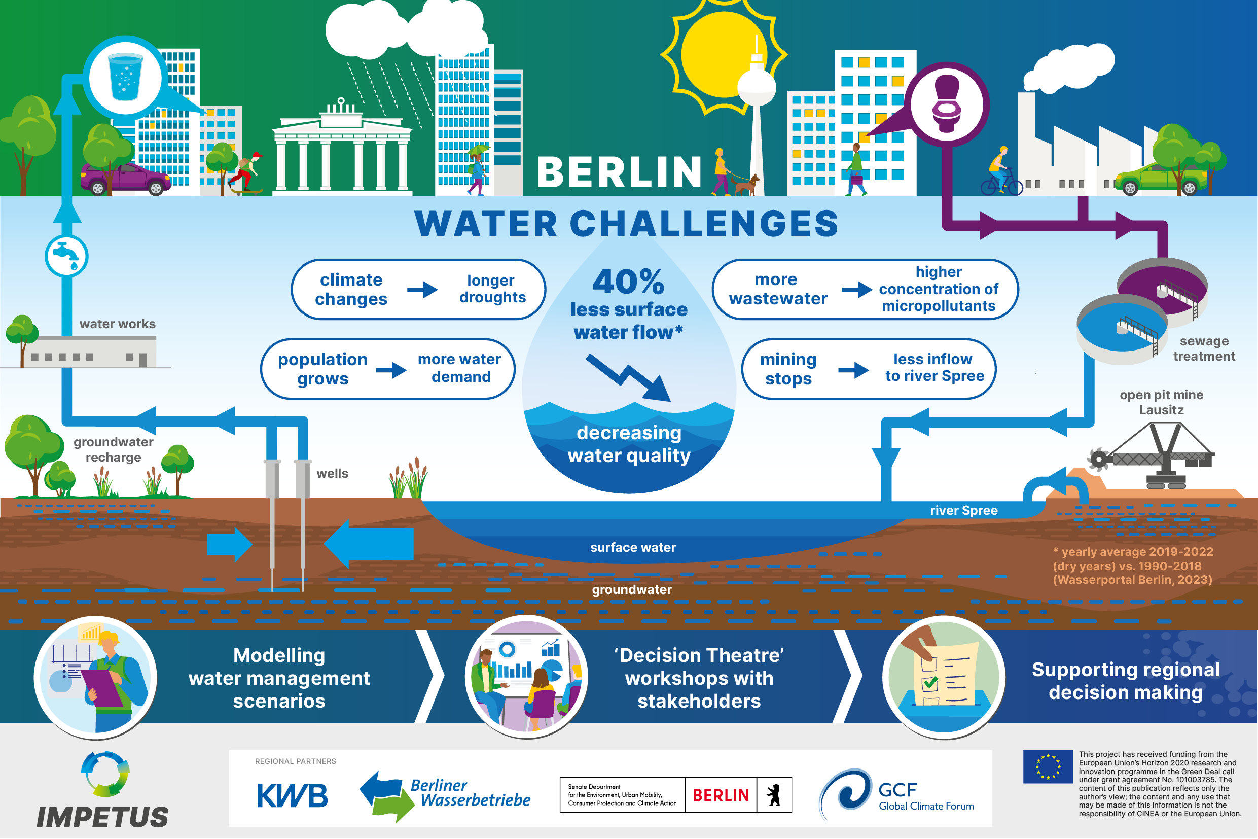
Berlin and its surroundings have a relatively high surface area of rivers and lakes. The city relies on riverbank filtration and groundwater recharge using surface water as its main sources for drinking water production. As some of the surface waters used for bank filtration are impacted by treated wastewater that is discharged upstream from wastewater treatment plants, the water cycle is partially closed.
The nearby open pit mine in Lausitz stays dry by pumping its groundwater into the river Spree, which is one of two major rivers flowing through Berlin. On average, one third of the river water comes from the open pit mine.
Berlin’s large population is expected to grow, meaning more wastewater will be produced.
Increasing amounts of treated wastewater will constitute a growing proportion of the total volume in the water cycle, as other sources are expected to dwindle. This raises the risk that micropollutants, such as trace residues from pharmaceutical products, become more concentrated, reducing water quality.
Quantity of water is the greatest concern:
- In recent dry years, the flow of surface waters was already half of the long-term average.
- The growing population will require more water for domestic use and for industry.
- The city’s growing water demand already conflicts with the needs for new industries, waterways usage (shipping, tourism) and natural habitats in the region.
- The amount of water available is expected to reduce within a few years, when the nearby Lausitz mine closes and stops pumping its groundwater into the river Spree.
Climate change is expected to exacerbate the situation by increasing the duration and frequency of droughts through higher temperatures and reduced precipitation.
To help Berlin’s water management and regional policy makers adapt to these challenges, the local IMPETUS partners are developing a digital model exploring different climate change scenarios and measures to mitigate the challenges.
The results will be used in ‘Decision Theatre’ workshops to engage local stakeholders in co-creation of solutions. And this will support sustainable decision making and a regional strategy for water management and climate change adaptation.
Ambitions within IMPETUS:
Map the trans-regional water cycle and water balance
(quantitative and qualitative)
Assess cross-sectoral, trans-regional vulnerability of critical water usages
Define and assess future scenarios including cross-sectoral water usage
Simulate future regional water balance scenarios
Reduce uncertainties in scientific models and analytical tools
Integrate data, models, tools and simulations in a Resilience Knowledge Booster
as a regional ‘toolbox’ and known information source
to pave the way for:
Establishment of a regional water board
(across federal state boundaries), negotiating water rights based on supply-demand scenarios
Vulnerability assessment and prioritisation of water usage
for various scenarios
Region to serve as a ‘lighthouse’ in the national water strategy
best-practice examples
Continuation of the Resilience Knowledge Booster
for regional and international adaptation activities.
Test solutions:
Integrated mapping and regional watershed modelling
Technology Readiness Level 7-9
Based on surface water, ground water and soil model coupling, this technology involves the operation of monitoring networks and the application of HYDRAX / QSIM / MODFLOW models to assess and manage water bodies and comply with the water framework directive.
In IMPETUS
- Over these modelling tools, analytical tools will be developed to assess regional water flows across the environmental compartments.
- SWAT+, FREEWAT and zeHGW models will be integrated for surface water-groundwater interaction.
- Earth data will be included for the projection of water levels and to assess impacts on land use.
- Scenarios of management of upstream surface water levels and waste water discharges to the Spree-Havel river system will be simulated.
This work is linked with:
- German Climate Adaptation Strategy (pdf, in German)
- German National Water Dialogue
- FREEWAT initiative
- SWAT initiative
Economic impact assessment of physical climate risk
Technology Readiness Level 4-5
Socio-Economic tools and risk projections enable the assessment of climate risks and the establishment of projections and metrics regarding future investments.
In IMPETUS
- Identify highly vulnerable hot-spots using open datasets for Copernicus services and satellite-derived variables.
- Transform this knowledge into a specific regional model and include this in the Resilience Knowledge Booster.
- Use the RKB and regional model to elaborate economic assessment metrics to aid decision making about investments and future mitigation plans.
This work is linked with:
- European Investment Bank
- European Central Bank