Prognosis
Global warming is particularly strong at high latitudes. Change in precipitation and wind patterns will alter snow conditions and affect risks of avalanches. Higher temperatures and change of winds and precipitation will affect aquaculture and change conditions for fishery. In addition, climate change will lead to sea level rise, more intense precipitation, and stronger storms which increase the risk of flooding and storm surges.
Situation
The IMPETUS Arctic demonstration site, Troms County, is situated in the northernmost mainland of Norway, beyond the Arctic circle. This region of 26 000 km2 shares its eastern borders with Sweden and Finland, and has 170 000 inhabitants.
Seafood (form fishery and aquaculture) and tourism are the largest economic sectors, in terms of income value to the region. In addition, reindeer herding plays an important cultural role. The region with its infrastructure and small communities is facing risk from landslides, rockfalls, avalanches and fjord tsunamis triggered for instance by landslides or rockfalls. These natural hazards may increase in severeness due to climate-change-driven changes such as warming, intense precipitation, unstable snow cover, glacial retreat, flooding and sea level rise.
Climate related problems

Sustainable management of fisheries and aquaculture
Climate change has already had a significant impact on fisheries and aquaculture in Northern Norway, e.g. though marine heatwaves facilitating more parasites and warmer seas causing changes in fish migration routes.

Increasing natural hazard risks
Increasing temperatures and precipitation give more natural hazard events such as landslides and avalanches.

Flooding and water management
Rising sea levels and increased precipitation increase risks of flooding and challenge the urban infrastructure and water management along the coast, both today and in a long-term perspective.
Key actions
- Marine spatial planning for marine protection and sustainable fishery.
- Assessment of future avalanche problems, development of avalanche-danger forecasting tools and early-warning systems, and suggestion of adaptation pathways to mitigate avalanche risks.
Awareness raising involving stakeholders, and risk assessment related to sea level rise and flooding in inhabited areas.
Contact us
Demonstration site leader
Rune Grand Graversen
rune.graversen[@]uit.no
Co-leaders
Marie Stetzler
marie.stetzler[@]uit.no
Kai-Uwe Eiselt
kai-uwe.eiselt[@]uit.no
Events
News


Navigating snow avalanche risks in Troms – Norway

Harnessing Earth Observation for Climate Change Solutions
Resources
Relevant sectors:
Municipality
Coastal zone planning
Public administration
Fishery
Aquaculture
Ski tourism industry
National road service
Urban planning
Citizens
Urban developers
Our ambitions
Climate change imposes threats to human life, infrastructure, and environment. We aim to provide knowledge and tools to plan for a safe transition of societies in the Arctic area. In our demonstration site we focus on coastal flooding, aquaculture and fishery, and snow hazards.
We develop a digital twin of a section of the coastal area in Northern Norway, Troms County. The digital twin will include relevant data for the area and provide 3D visualisation techniques.
We aim at contributing to the adaptation and climate-proofing of Tromsø city’s infrastructural systems, such as urban water management and a municipality project on climate adaptive development along the waterfront. We will also improve prognoses of future snow hazards and suggest solutions to mitigate these.
Our goal is that the developed tools can be adopted by planners to meet the climate challenges of the future and mitigate risks.
- Introductory meetings with stakeholders
- Introduce and engage key stakeholders to the digital tools and solutions being developed
- Develop digital tools
- Test digital tools with stakeholders and gather feedback
- Public engagement
- Apply and further integrate tools to support decision makers within the region
- Share tools and knowledge with others
Issues
- Fishery productivity and suitability of sites for aquaculture are impacted by global warming, sea level changes, oceanographic variables, and frequency and magnitude of extreme weather events.
- More precipitation and extreme weather exacerbate these problems and increase physical and biological risks, such as harmful algal blooms.
- Landslides, rockfalls, and avalanches become increasingly likely with global warming as climate change enhances intense precipitation, unstable snow cover, permafrost thawing, glacial retreat, and groundwater changes.
- Communities and infrastructure become threatened by fjord tsunamis, river blockages, and destruction by landslides and rockfalls if high-risk slopes destabilise.
- Commercial and industrial sites become affected by flooding from extreme sea levels in low-lying areas.
- The northern location and climate change may affect urban water systems.
Region-specific solutions
Early warning system for avalanches, rockslides, or landslides

The risk posed by natural hazards on Arctic communities is expected to change as the Arctic becomes warmer and wetter under climate change.
To mitigate this risk, early warning systems, hazard maps and other avoidance measures can be used as a risk-reduction strategy. Two types of gravitational natural hazards occurring in the Arctic are slushflows and rock avalanches. A greater understanding of the physical processes taking place during hazard events, and of the initiation/timing of events, can help authorities to fine-tune the early warning and forecasting systems. This could also lead to enhanced risk reduction in the form of planning avoidance measures.
Our approach:
- Increase the understanding of movements in unstable rock slopes and how weather and climate may lead to catastrophic rock avalanches. Data produced from the monitoring of the high-risk, unstable rock slope Gámanjunni-3 in northern Norway will be analysed for movements under different weather and temperature changes.
- Develop a method for hazard mapping of the slushflow hazard. Development of a classification system for wet- snow avalanches andto slushflows is necessary to describe the diversity of behaviors observed.
This work is linked with:
Digital Twin for freshwater and marine management

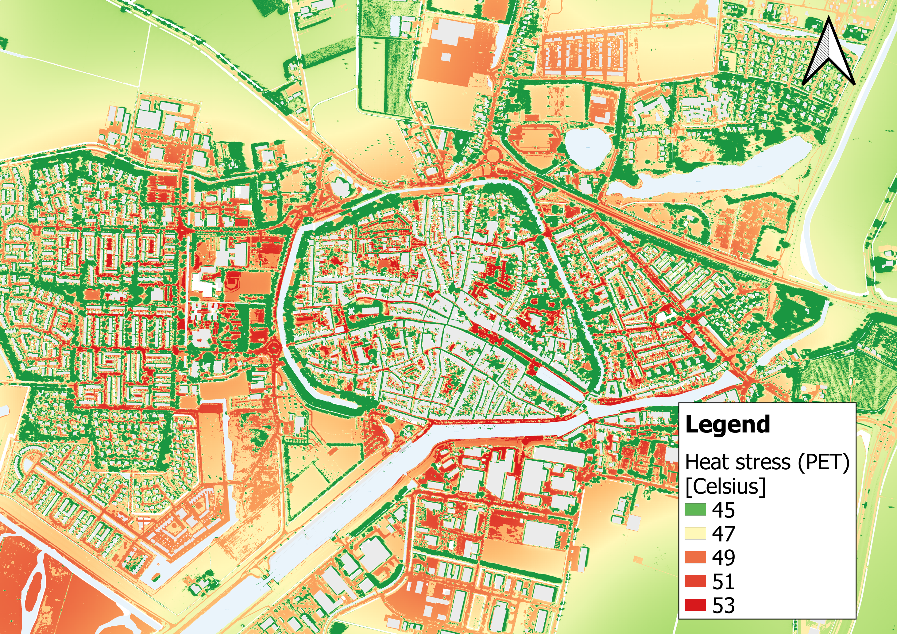
Evaluation of climate change risks is traditionally undertaken by combining impact modelling under different climate scenarios, with vulnerability and exposure assessments.
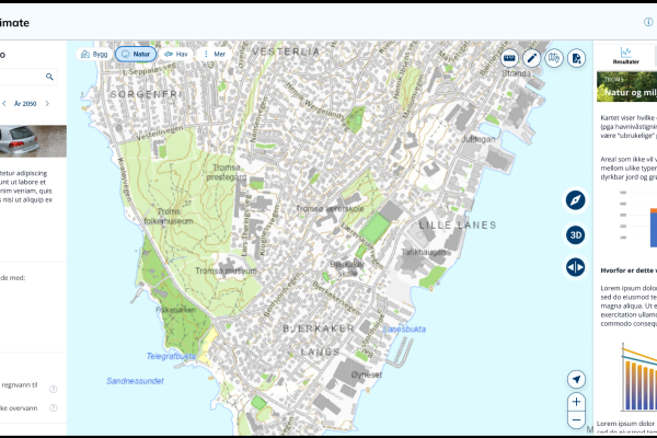
In most planning situations, the risk assessment is generated by overlapping different Geographic Information System (GIS) data layers. This is an effective methodology, which, however, is not easy for non-technical people to use or interpret. It is therefore difficult to use within stakeholder co-design processes.
Our approach:
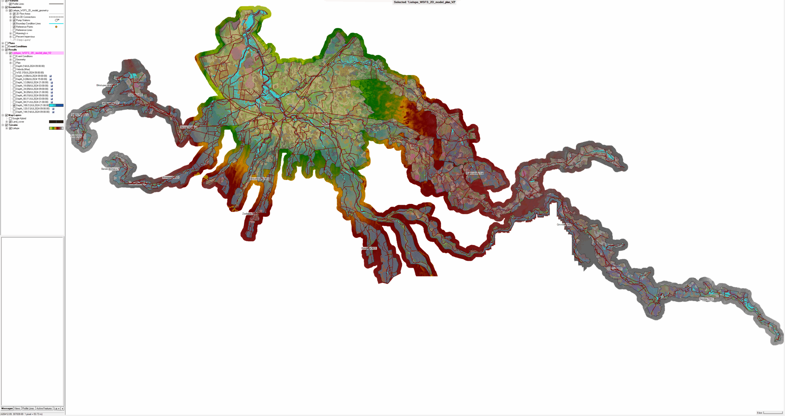
- Demonstrate the potential of using state-of-the-art GIS representation of multiple variables with 3D visualization techniques.
- Generate a digital twin of the region, providing visualisation of risk areas and possible impacts in an effective and user-friendly way.
- Use the digital twin to support the co-design of Marine Spatial Planning decisions for better planning of fishery, aquaculture, and other marine uses.
- Use the digital twin to support the co-design of climate-proofing actions to protect coastal cities from sea-level rise, storm surge, and flooding.
Our approach focuses on the co-creation of solutions by actively involving key stakeholders in both the design and validation of the tools. We use open datasets from national spatial data infrastructures and the Harmful Algae Event Database (HAEDAT).
This work is linked with:
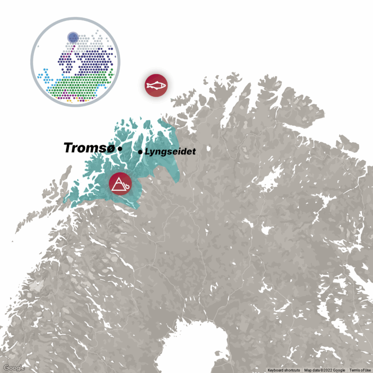
- Troms County Marine Spatial Planning programme 2021-2024
- EU Destination Earth Initiative, DestinE
- Water Framework Directive, Digital Single Market Strategy
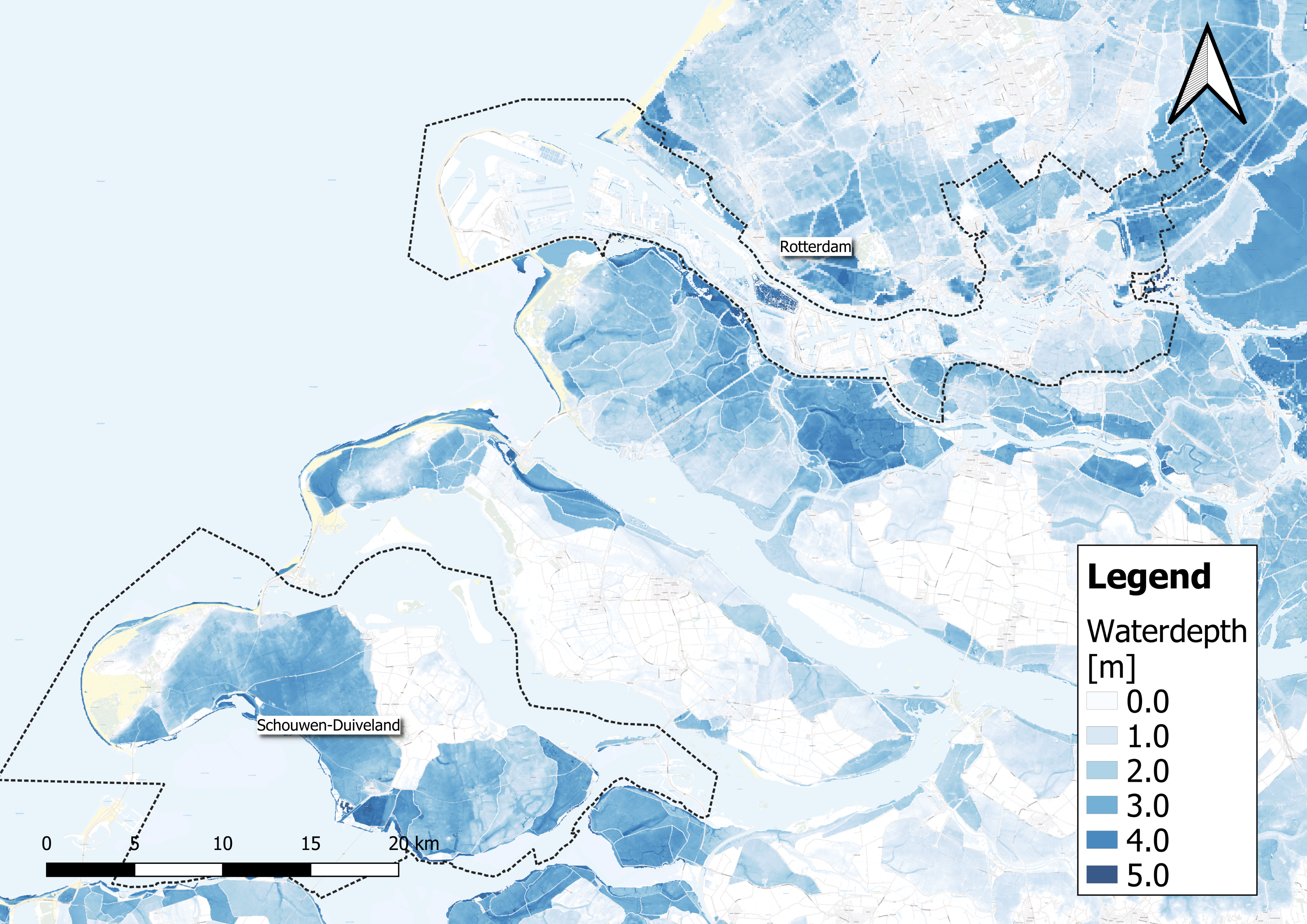
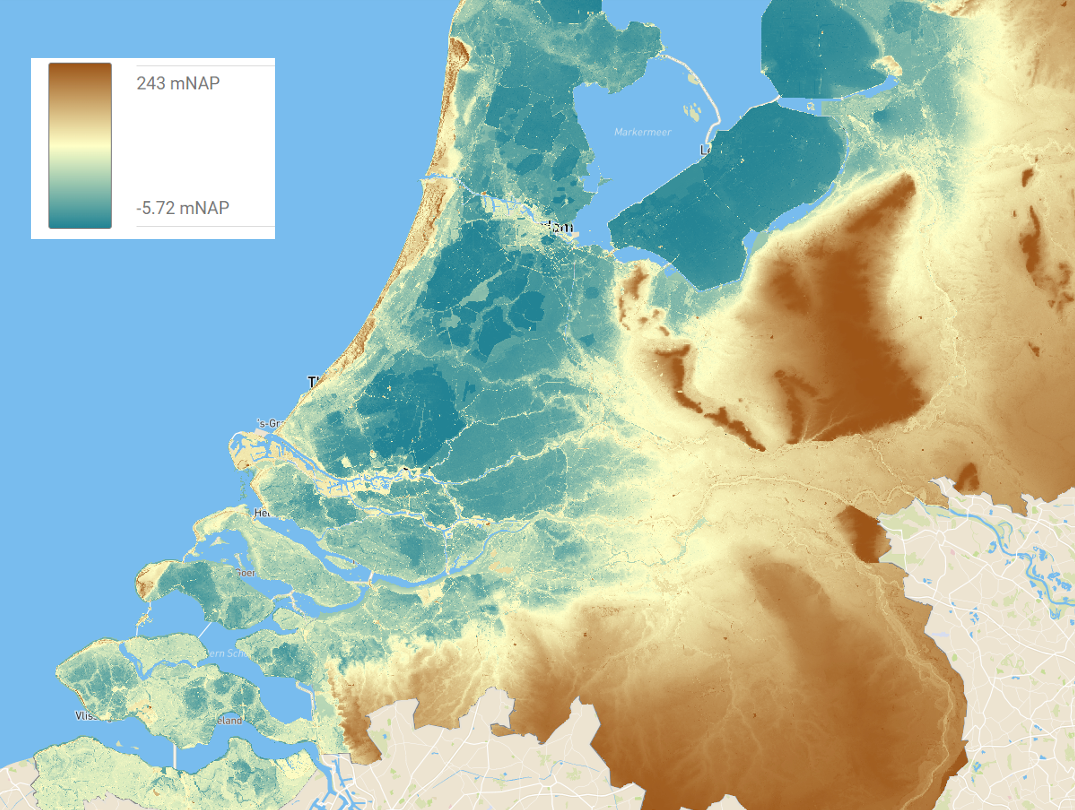
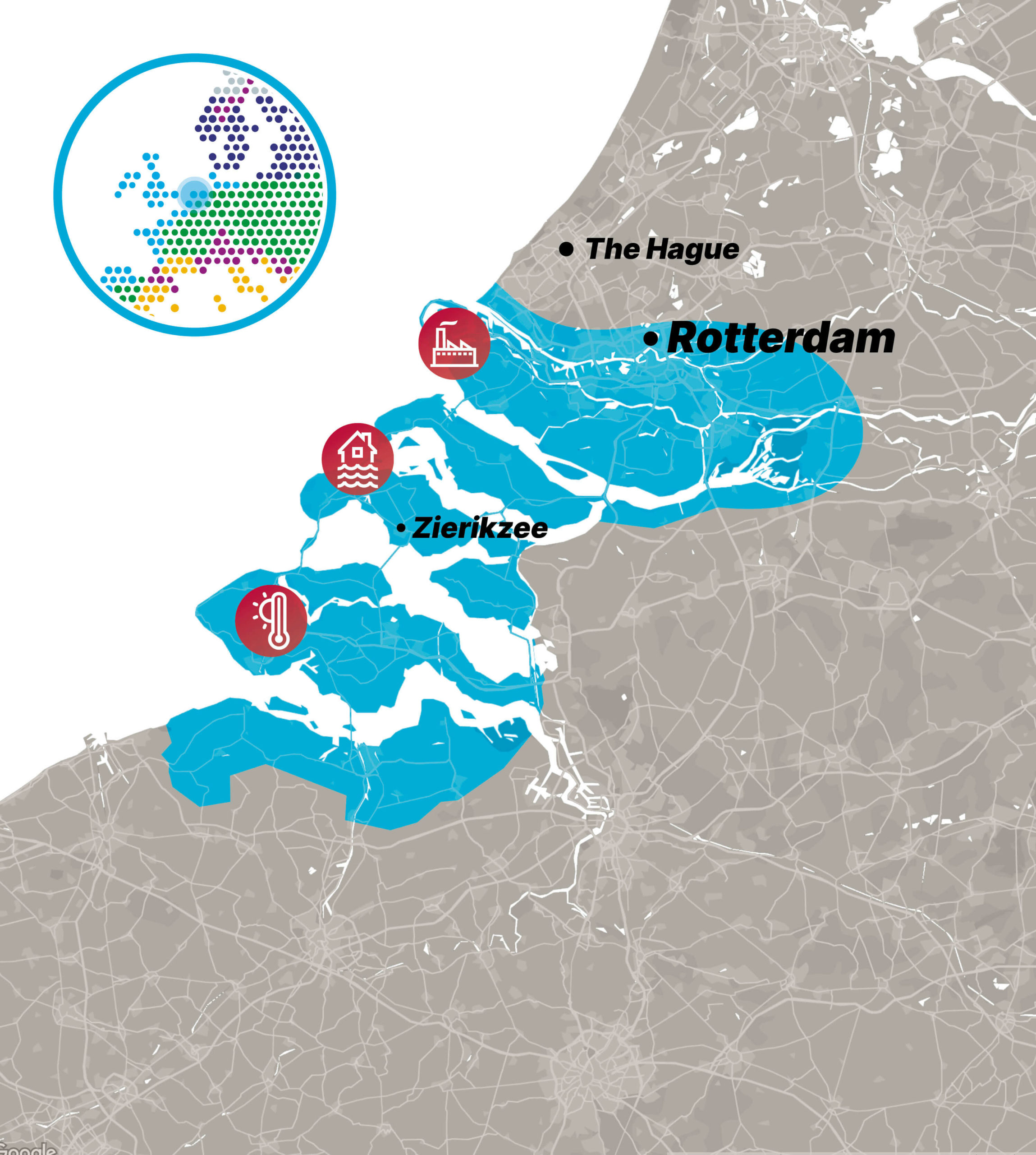
- Netherlands Delta Program
- Greenathon by the Hellenic Ministry of Environment and Energy


