Enhancing climate resilience in Athens through climate mapping

| |

After introducing the climate challenges in Greece and other countries in the Mediterranean, with Professor Christos Makropoulos from the National Technical University of Athens we take a closer look at the potential of resilience tools like the “Hotspot Explorer”  – a climate vulnerability assessment tool that can support proactive measures to mitigate climate risks.

Athens as a case study for cities and communities across the Mediterranean

Athens, with its unique geographical setting and dense urban environment, faces significant climate challenges that require urgent attention. As Prof. Christos Makropoulos explains, the city’s proximity to mountains creates a boundary where the urban and natural environments intersect, leading to heightened stresses. These challenges are exacerbated by the region’s vulnerability, characterized by hot Mediterranean climate, water scarcity, and limited green spaces.

IMPETUS Project partners are working hard to ameliorate the situation for this Greek region, especially in light of historical catastrophes like forest fires and urban floods. While these events are not solely attributed to climate change, they underscore the need for improved urban planning, disaster resilience, and decision-making processes. With the anticipation of harsher stresses in the future, adaptation and resilience become paramount.

Identifying climate vulnerabilities – the IMPETUS Hotspot Explorer

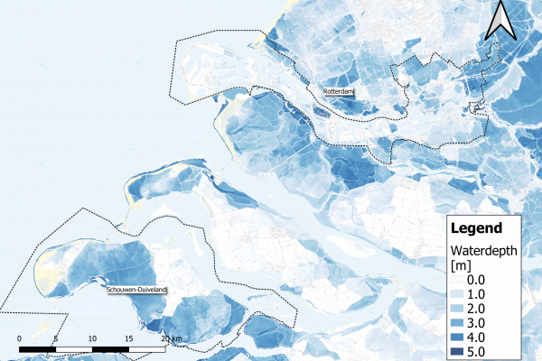
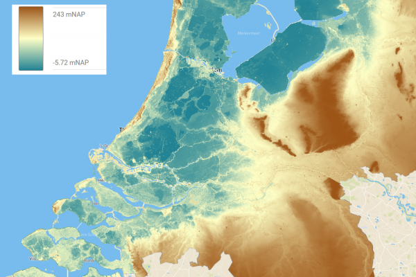
One of key solutions driven by IMPETUS partners activities in Greece is the “Hot-spot Identification and Prioritisation Service” – also know as the “Hotspot Explorer”. Developed by the National Technical University of Athens, it is an innovative mapping tool designed to identify climate hotspots within urban areas and beyond. This interactive map integrates earth observation data, climatic information, and local socio-economic factors to prioritize areas requiring immediate attention. By pinpointing critical issues and vulnerabilities, policymakers and stakeholders can initiate targeted interventions for meaningful change.

Identifying climate hotspots involves a nuanced approach that considers both environmental stresses and societal vulnerabilities. The Hotspot Explorer bridges this gap by matching climate data with local adaptation capacities, ensuring a holistic understanding of each area’s resilience needs. This comprehensive assessment enables informed decision-making and proactive measures to mitigate climate risks.

A tool to monitor climate changes across Europe and foster cooperation 

As climate challenges persist, initiatives like IMPETUS, which fall under the scope of the EU Mission: Adaptation to Climate Change, aim to inspire communities to embrace adaptation and innovation in the fight against climate change. While Athens faces unique challenges, by leveraging cutting-edge technologies like the Hotspot Explorer, the project offers a climate resilience model that can be applied to similar urban environments across the Mediterranean and beyond.

By fostering collaboration between government policymakers, technological innovators, and academic institutions, IMPETUS aims to drive policy initiatives and technological advancements hand in hand. This synergy holds the potential to create tangible impacts, paving the way for a more resilient and sustainable future.

*The Hotspot Explorer is currently in an initial beta version, with a major update expected in September 2024.

Watch interview with Prof. Christos Makropoulos 

icon_heat

High temperatures

Record-breaking summertime temperatures have been recorded in the Netherlands in recent years. With global temperatures rising, such extreme weather events will occur more often, and for longer periods. Prolonged high temperatures, with warm nights as well as hot days, can cause heat stress* and related health issues, particularly among city populations.

*Heat stress occurs when the human body cannot get rid of excess heat and can impact wellbeing through conditions such as heat stroke, exhaustion, cramps and rashes.

"We want to enable municipality decision makers who are working on spatial developments to identify heat stress 'hot spots' and cool areas, analyse the future effects of climate change, and model the effect of different heat stress-reducing measures. The tool must provide them with an easy starting point to integrate heat stress risks in their projects."

Issue

Despite the cooling effect of the sea in the region of Zeeland, the growing risk of heat stress has become a concern.

Elderly and other vulnerable people are more impacted by the effects of prolonged heat, which can cause headaches, dizziness, insomnia and other health issues – even death. Excess temperatures also affect general comfort and liveability of cities. Water quality can be reduced, both for drinking and swimming, and infrastructure can be affected. Buildings and concrete surfaces trap heat, potentially leading to damage, and release it during the night, keeping temperatures warm.

During heat waves, it is important that everyone has access to a cool and comfortable place. Appropriate spatial planning can help to decrease and deal with heat stress. Environmental factors like water bodies, trees, and shade have a major impact on stress caused by high temperatures. Therefore, planting trees, removing concrete surfaces, creating green roofs and cool spaces can improve our comfort and health. The IMPETUS Atlantic team is developing a digital tool to support regional decision making for city planning to address these needs.

icon_flood

Flood risk

By 2050, sea-level within this region is predicted to rise by 15-40 cm, with more frequent extreme weather and more (severe) storms triggered by climate change. These changes will exacerbate the natural risk of flooding in the IMPETUS ‘Atlantic’ region, because it is surrounded by rivers and the sea, and is below sea level.

*Risk takes into account two aspects; the chance that an event will occur and the negative impact of such an event once it occurs. When there is a low chance that an event will occur, but its impacts are huge, the risk is still significant.

“In the Netherlands, an extensive system of dikes protects us against sea and river flooding. We have always put our faith in this defence and focused almost solely on flood prevention. However, pressure on our system will increase with climate change and rising sea levels. To adapt and maintain a safe living environment, we should develop other safety measures, like more robust spatial planning and contingency plans."

Issue

Rotterdam city, is located in Rijnmond – ‘mouth of the Rhine’. The Rhine river flows through this densely populated area and characterises the region. Protections such as sea dikes and storm surge barriers have been constructed to protect the region, but flooding still occurs.

People living in the city are accustomed to seeing smaller floods. The changing climate affects the interplay between rainfall, river levels and sea storms, increasing the flooding risk. Water levels could rise by a few metres, even in populated areas, with potentially massive impacts. 

Mitigation measures such as storm surge barriers reduce the chance that high water reaches the city, but to minimise the impact of floods when they do occur, adaptation strategies are also needed. A city that can adapt to be safe from floods must be carefully designed. How best to design such an adaptive city?

Critical infrastructure, such as hospitals and evacuation routes, must be accessible at all times. Planning how to best protect them, homes and lives is complex. Flood water behaves in a complex way and flood risks show strong spatial variations. The IMPETUS Atlantic team is developing a digital tool to support regional decision making for adaptive city planning. 

icon_factory

Energy and waste water

To become climate-neutral by 2050, climate mitigation* efforts are crucial in our strategy for how to deal with climate change. Reducing our energy consumption is a significant mitigation step. In the Netherlands, 15% of energy is consumed in the Rijnmond area around the port of Rotterdam, in large part by a major petrochemical industry cluster.

*Climate mitigation encompasses measures such as technologies, processes, or practices that reduce carbon emissions or enhance the sinks of greenhouse gases.

Issue

The Rotterdam port petrochemical industry cluster is Europe’s largest. It consumes 70% of the Rijnmond region’s energy. A large part of this energy is wasted (64%, 203 petajoules). More than half of that energy is lost with wastewater. In addition, most energy processes within these industries rely on fossil fuels, which has a significant impact on the climate.

Energy use must be minimised and fossil fuels should be replaced by renewable sources if climate change is to be mitigated. Electrification of processes opens up the possibility to use more renewable energy and can greatly impact decarbonisation. Recovering wasted heat would significantly reduce energy consumption and is a first step towards a more circular industry. 

Supporting industries in a transition towards climate-neutrality depends on identifying how best to reduce their carbon footprint without sacrificing production or performance. The IMPETUS Atlantic team is creating a digital tool that supports decision making about pathways towards an effective energy transition for EU industry.