Mountains demo site

Valle dei Laghi area, IT

{{ group }}

{{ object.name }}
{{ object.name }} {{ object.subheader }} {{ icon.replace(/^icon_/, '') }}

Prognosis

Rapid climate change impacts will lead to increasing conflicts in water and land usage, for this reason IMPETUS is seeking to promote participatory approaches in decision making to ensure rapid transition to sustainable and integrated water management, biodiversity conservation and disaster risk reduction.

Situation

The Valle dei Laghi area is located in the Province of Trento in the Italian Alps. The area has an abundant water supply and a very fragmented population, with small villages and municipalities with less than 5000 inhabitants.

Agriculture and food / wine production, hydropower production, forestry for wood fuel, slow tourism and winter ski tourism are the main economic activities. The Alps, and mountains in general, are recognised hotspots for climate change, with temperatures raising far beyond the average and more frequent extreme weather events.

Climate related issues

Water use

Water scarcity and lack of preventive actions to manage it; water management conflicts.

Land use

Loss of local traditions in agriculture and cultural heritage

Economic impacts

Increased frequency of extreme events and related economic and social damages

Key actions

Thanks to data and knowledge sharing and co-creation with local actors, we are supporting decision-making processes to strengthen the resilience of the territory and the community in the following fields:

  • sustainable and integrated management of regional water resource through a Decision Support System;
  • analysis of innovative insurance products for agriculture;
  • evaluation of the effects of the altitudinal shift of crops on vineyards;
  • activating the cultural heritage to enhance climate resilience;
  • applying Impact Chains approach to better understand and manage vulnerabilities and risks related to climate change.

Relevant sectors:

Municipality

Citizens

Farmers

Energy

Biodiversity

Our ambitions

ā€œDespite the name (Valle dei Laghi means Lakes Valley), in this area rapid climate change impacts are leading to increasing conflicts in water and land usage.

For this reason within the IMPETUS project, we are promoting participatory approaches in the decision making process, involving different local stakeholders, to ensure rapid transition to sustainable and integrated water management, biodiversity conservation and disaster risk reduction.ā€

Valentina D’Alonzo, European Academy of Bolzano (EURAC)

In the mountain demonstration site, we have set ambitious goals:

  • Harmonise and build on existing solutions and initiatives to develop a multi-sectorial / multi-systems innovation package for the region.
  • Use operational climate services and products such as satellite data, seasonal forecasts, climate projections to develop co-created medium to long-term plans for water usage and risk management.
  • Ensure local community ā€˜ownership’ of risk management solutions integrating risk analyses and management approaches with participation, communication and co-creation.
  • Promote adaptation solutions uptake and transfer to other mountain communities engaging with national and international stakeholders.
  • Setting the stage for a network of citizens and stakeholders for their long-term participation in the decision-making process.
  • Demonstrate and test the developed solutions for wider uptake at provincial and higher levels as part of a Provincial Strategy for Climate Change Mitigation and Adaptation.

Issues

Region-specific solutions

Enhanced knowledge and data-driven support for insurances related to the agricultural sector

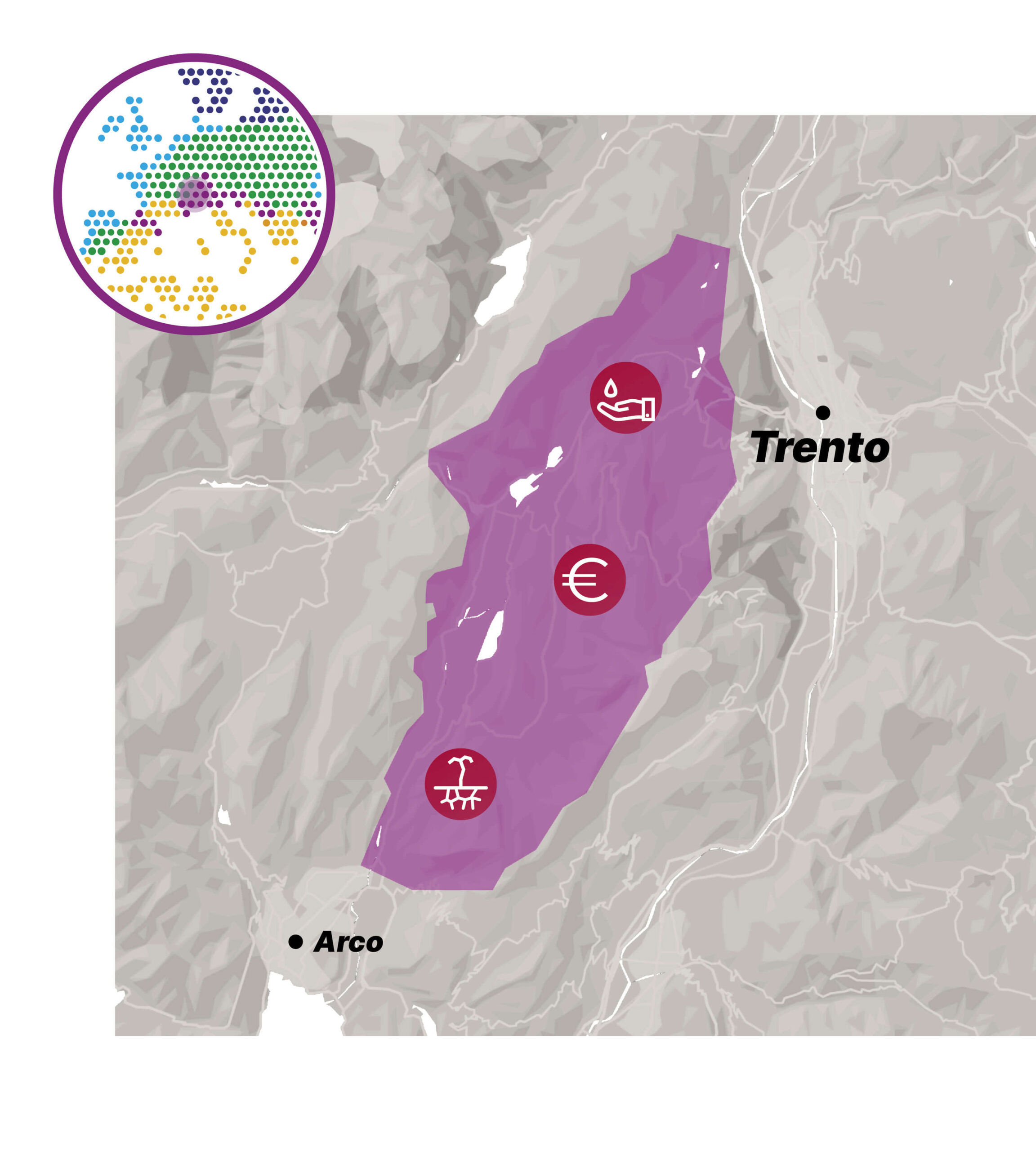
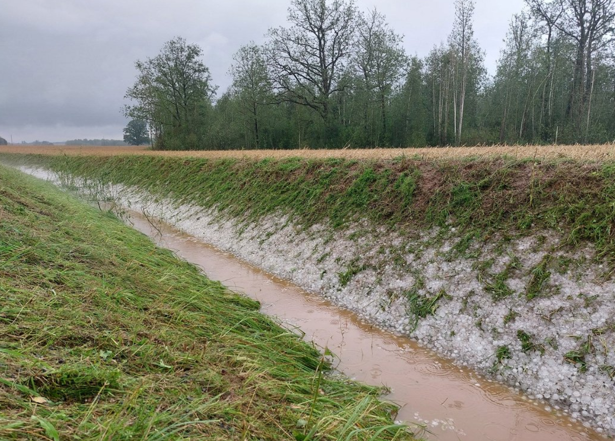
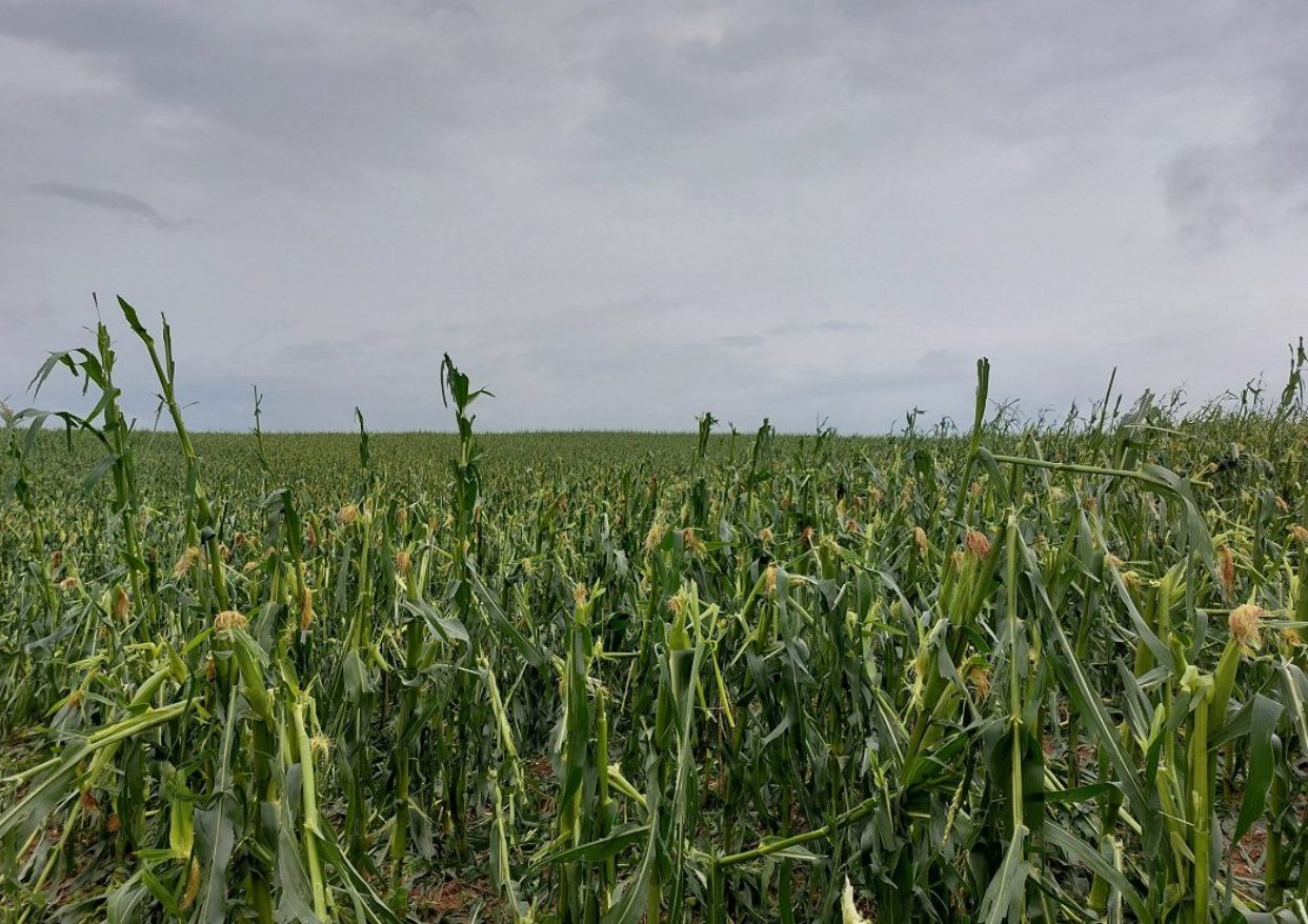
Parametric or index-based insurance products – offering pre-specified pay-outs on the basis of climate change triggered events – would provide passive protection measures or sustainable financing instruments to invest in active protections such as hail nets, drip or top crown irrigation.

Our approach:

  • Design and test such an insurance system to protect agricultural crops, forest stands and hydropower energy plants against climate-related economic losses;
  • Involve stakeholders and experts from agricultural insurance consortia and ethical banking;
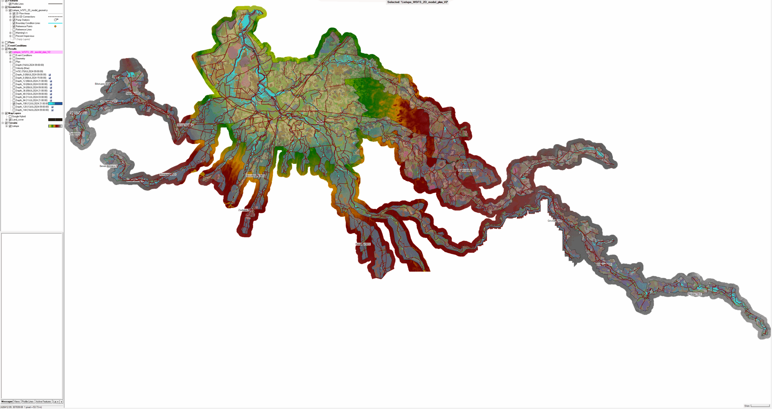
  • Support the design of insurance and financing models with tailor-made climate risk assessment tools that exploit existing data platforms providing seasonal forecasts and climate projections (e.g., Copernicus, Geo Mountains), enriched by local-scale data, and impact models;
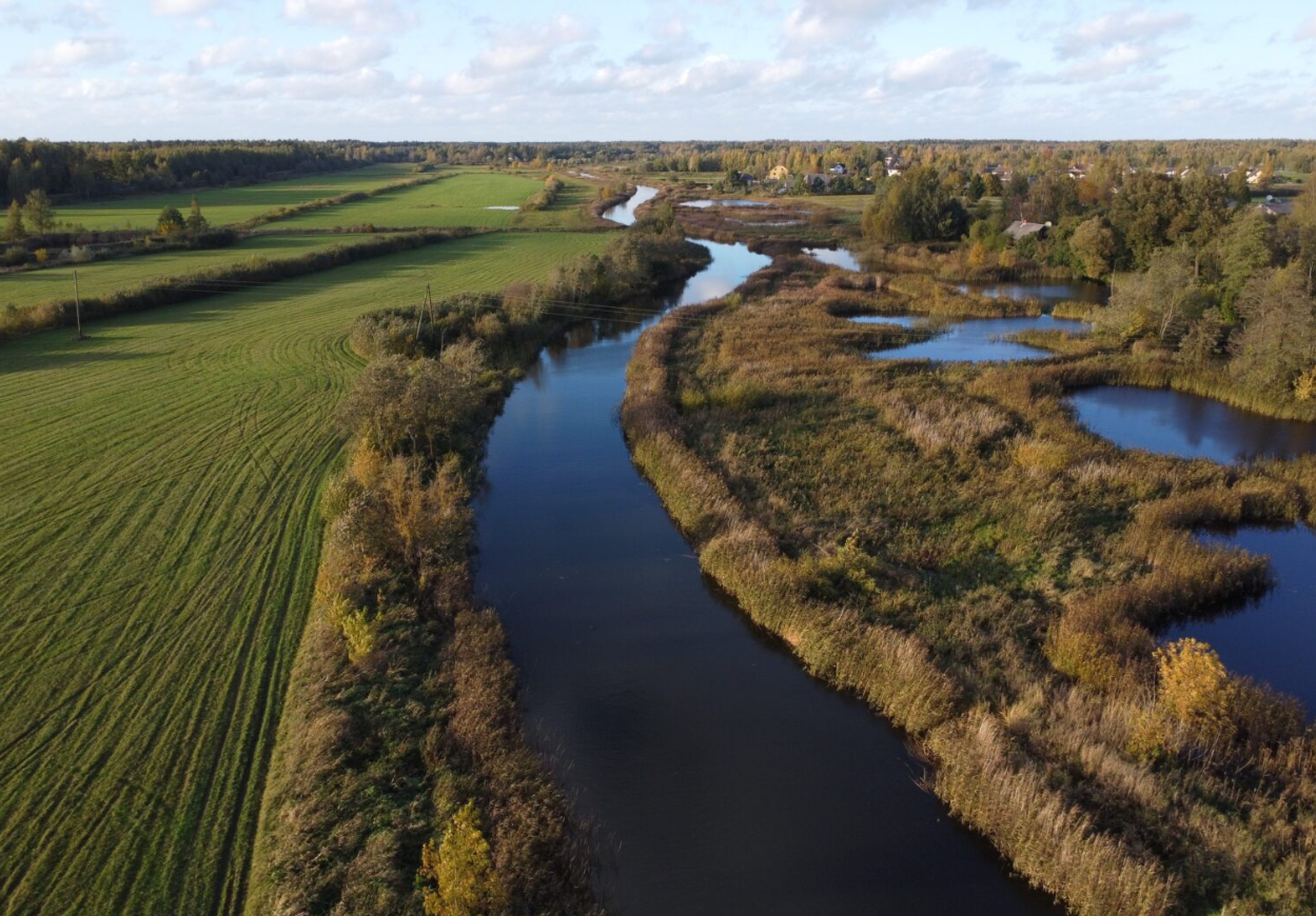
  • Allow the economic evaluations to be based on assessment of future return periods for adverse climate events, such as hail, storms, floods, droughts, forest fires, etc.
This task will help to increase the know-how and knowledge sharing to identify the best indices (climatic and non-climatic) and forecast models that can support drought risk analysis and management for selected crops.

Activate cultural heritage to enhance climate resilience

In the context of global climate change, mountains are predominantly facing an increase of already existing, locally occurring natural hazards of reversible risks. Although their potential to cause damage is high, they are well known to the resident communities, who have been dealing with such threats for decades or centuries. Therefore, at local and regional level, a thorough understanding of how to cope with these risks has evolved.

Our approach:

  • Tap into the regional endogenous knowledge, revealing how culture, values and beliefs influence risk perceptions and enable or impede climate adaptation measures;
  • Identify relevant cultural practices in agriculture, water management and buildings regarding their potential for further development, upscaling and transferability, showcasing local best practices in terms of cultural practices to leverage for climate mitigation and adaptation;
  • Identify and exploit the interconnected intangible and tangible components of cultural heritage that are an essential part of local identities and shared values;
  • Develop tools to foster societal awareness and facilitate win-win solutions for adaptation and implementation of low-carbon measures for historic buildings analysing the existing building stock to investigate its past, present and future performance.
This task will help to detect triggers of behavioural change that can be applied in innovative climate change adaptation pathways.

Apply Impact Chains in participatory processes

Impact Chains (IC) provide a structured graphical and conceptual narrative of causal relationships between adverse impacts and the components that drive and constitute them. The IC approach has been widely applied to better understand vulnerability and risk related to climate change, notably by the Intergovernmental Panel on Climate Change, and has been used for risk assessment in climate change adaptation planning at local / national level in more than 10 countries. Step-by-step guidelines on how to adopt the IC methodology are available and internationally acknowledged and are regularly being updated.

Our approach:

  • Involve local experts in the Mountains demo site in a participatory process;
  • Development of Impact Chains for the Valle dei Laghi DS, focusing on the agricultural and built environment sectors;
  • Analyse risk management practices in order to identify gaps, points for improvement as well as best practices;
  • Pinpoint in which field adaptation measures need to be taken;
  • Use the results to foster behavioural change and increase communities’ awareness and adaptive capacity;
  • Replicate this activity in other mountainous areas to foster mutual learning and exchange of best practices;
  • Exploitation of the Impetus IC application to develop practical guidelines for practitioners and researcher to apply the IC approach.
The Impact Chains can help sectoral experts to obtain a conceptual representation of risk and to identify gaps in risk management and entry points for climate change adaptation.

Decision Support System integrating multiple information layers for the sustainable and integrated management of regional water resource

Seasonal hydrological forecasts are a rather new climate service, essential for anticipating the occurrence of droughts and floods and for managing water use conflicts. The DSS will be based on a digital twin that uses a hybrid approach combining physically based hydrological models and machine learning to create these forecasts.

Our approach:

  • Use seasonal hydrological forecasts to feed a participatory Decision Support System (DSS) for the integrated and sustainable management of concurrent water uses;
  • Ensure this happens in the framework of the WEFE (Water Energy Food Ecosystems) nexus approach and takes into account environmental, economic and political constraints;
  • Develop the DSS to allow the design of (i) seasonal management strategies to better cope with drought periods and operation of water levels in hydropower reservoirs for energy production in small and large plants; (ii) longer-term management strategies concerning smart irrigation, ecosystem protection and hydropower plants revamping.
This IMPETUS decision support system will help decision makers to take well-informed decisions on water management in water scarcity situations.
icon_storm

Extreme events

Reports from European Environment Agency indicate that over the past decades, Europe has been experiencing frequent and severe weather and climate-related natural hazards likeĀ droughts, forest fires, heatwaves, storms and heavy rain. Climate change will make these events even more intense and more frequent. The summer of 2024 was the hottest on record for Europe and globally. While up to recently the extreme events were not considered usual in Zemgale region, experience from few previous seasons raise precautions. In summer 2024, there were heaviest rains that Latvia has experienced since 1945.

The impact of various extreme weather events has been particularly pronounced in places with high population density, such as the city of Jelgava. The region’s flat topography and land surface elevation relative to sea level result in high groundwater levels, which place additional stress on the city’s drainage and storm water drainage systems.

Issue

In Jelgava, the main challenges from rainfall include high risk of flooding and damage to infrastructure during prolonged rainfall. The Lielupe River and its tributary floodplains, as well as low topography and high-water tables, make drainage and stormwater drainage systems difficult to operate. The extreme rainfall of July 2024 confirms that the existing sewerage system is inadequate to cope with such situations.Ā  In the region’s rural areas, the threats affect both settlements and villages and fertile agricultural land, which plays an important role in the region’s economy.

Storms are the second most pronounced weather extreme in the region and, although on average winds are not expected to change significantly over the 21st century, by the end of the century (relative to the period 1971-2000) there will be a greater number of both windless days and stormy days per year.Ā  In recent years, the Zemgale region has been severely affected by thunderstorms and storms that have brought heavy rainfall in the form of both rain and hail, destroying agricultural crops and damaging infrastructure in many places. Severe storms in summer and early autumn, when trees and shrubs are still in leaves, have caused severe damage.

Climatologists believe that the current extreme values will become the norm in the future, while extreme weather events will cause even more damage. Climate models also predict an increase in total annual precipitation over the 21st century, with an average annual precipitation in Latvia of 775.7 [±60.0] mm for minor, 806.5 [±72.8] mm for moderate and 814.2 [±79.7] mm for major climate change. Predictions foresee substantial increase in duration of heatwaves from climatic norm of 8 days to 16 [±8] days for minor, 22 [±9] days for moderate and 33 [±12] days for major climate change.

Forecasting extreme weather events is quite complicated task, as these events are characterized by short-term nature, they and spatially limited, and thus short warning times are operational. Measures for adaptation to climate change thus become essential by preparedness for more days with extreme temperatures and for more extreme precipitation events. Decision-makers and local authorities need data and information to make the necessary preparations in advance by adapting to the different scenarios and possible consequences.

Within activities of IMPETUS project, the Adaptation Pathways are elaborated for Zemgale region with particular focus on flooding occurrences from river spring floods and heavy rain events:

  • Adaptation pathways are developed to support in better management of river flood risks and heavy rain floods (flash floods).
  • Aimed to implement a set of measures for reducing the frequency and extent of flooded areas in both rural (agricultural) land and urban settlements.
  • In exchange with the stakeholders, adaptation options are identified, assessed and included in the pathways to increase adaptive capacity in Zemgale region.
  • Structural measures, e.g., upgrading of existing drainage and stormwater drainage systems, and aligning them with nature-based solutions for water retention in rural and urban areas, and cleaning of riverbeds are considered.
  • Non-structural measures for improving flood risk early warning system (EWS), increasing awareness of inhabitants and improving the efficiency of actions of competent authorities in case of floor risks are addressed.
icon_flood

Flooding

Zemgale is a very flat region, located in a lowland area with a high density of rivers. The Lielupe River is characterized by its slow course, due to Zemgale’s flat topography and the low gradient of the riverbed. The height of the Lielupe floodplain does not exceed 1 m above water level. Downstream of Jelgava, the Lielupe River drops only 5-10 cm/km. The riverbed is much lower than the average level of the Baltic Sea.

Issue

Climate change in the Zemgale region by the end of the 21st century will have a major impact on the hydrological regime.Ā  One of the most significant changes will be increased precipitation: under a moderate climate change scenario, winter precipitation will increase by 24-38%, while under a significant climate change scenario, precipitation is expected to increase by as much as 35-51%. Maximum daily precipitation will increase by about 3-6 mm, in some places by as much as 10-12 mm. On a seasonal basis, the greatest increases in precipitation are expected during the winter and spring seasons, so that the risk of flash flooding increases significantly during the cool season, when evapotranspiration is not intense. Periods of high rainfall will alternate with prolonged droughts, which will have a particular impact on heavy rainfall events, increasing the frequency of flash floods. During heavy rainfall, short, localised flooding can be observed in both larger and smaller towns, as well as in flat rural areas.

One of the activities in Zemgale in the IMPETUS project is the improvement of the Flood Early Warning System using the HEC-RAS 2D model. This model simulates water flow in two dimensions, which is particularly useful for flood modelling and forecasting. The HEC-RAS 2D model uses two-dimensional Diffusion Wave Equations to calculate the water flow. The developed model performs 2D

Key Benefits of Using Such a Hydraulic Model

  1. Accuracy and Detail: The HEC-RAS 2D model provides high accuracy and detail, which is essential for flood risk assessment and management.
  2. Integration: The HEC-RAS 2D model can be integrated with other geographic information systems (GIS), facilitating data processing and visualization.
  3. Early Warning Systems: The model is crucial for the development of early warning systems, as it allows for the prediction of flood spread and impact, thereby helping to timely warn residents and take necessary measures.
  4. This solution automatically reads hydrological forecast data from the forecast system of the Latvian Environment, Geology and Meteorology Centre.

These model results are crucial for the operation of the Early Warning System, which uses this data to identify potential flood areas and prepare warnings at the property (cadastral unit) level.

icon_heat

High temperatures

Record-breaking summertime temperatures have been recorded in the Netherlands in recent years. With global temperatures rising, such extreme weather events will occur more often, and for longer periods. Prolonged high temperatures, with warm nights as well as hot days, can cause heat stress* and related health issues, particularly among city populations.

*Heat stress occurs when the human body cannot get rid of excess heat and can impact wellbeing through conditions such as heat stroke, exhaustion, cramps and rashes.

"We want to enable municipality decision makers who are working on spatial developments to identify heat stress 'hot spots' and cool areas, analyse the future effects of climate change, and model the effect of different heat stress-reducing measures. The tool must provide them with an easy starting point to integrate heat stress risks in their projects."

Issue

Despite the cooling effect of the sea in the region of Zeeland, the growing risk of heat stress has become a concern.

Elderly and other vulnerable people are more impacted by the effects of prolonged heat, which can cause headaches, dizziness, insomnia and other health issues – even death. Excess temperatures also affect general comfort and liveability of cities. Water quality can be reduced, both for drinking and swimming, and infrastructure can be affected. Buildings and concrete surfaces trap heat, potentially leading to damage, and release it during the night, keeping temperatures warm.

During heat waves, it is important that everyone has access to a cool and comfortable place. Appropriate spatial planning can help to decrease and deal with heat stress.Ā Environmental factors like water bodies, trees, and shade have a major impact on stress caused by high temperatures. Therefore, planting trees, removing concrete surfaces, creating green roofs and cool spaces can improve our comfort and health. The IMPETUS Atlantic team is developing a digital tool to support regional decision making for city planning to address these needs.

icon_flood

Flood risk

By 2050, sea-level within this region is predicted to rise by 15-40 cm, with more frequent extreme weather and more (severe) storms triggered by climate change. These changes will exacerbate the natural risk of flooding in the IMPETUS ‘Atlantic’ region, because it is surrounded by rivers and the sea, and is below sea level.

*Risk takes into account two aspects; the chance that an event will occur and the negative impact of such an event once it occurs. When there is a low chance that an event will occur, but its impacts are huge, the risk is still significant.

ā€œIn the Netherlands, an extensive system of dikes protects us against sea and river flooding. We have always put our faith in this defence and focused almost solely on flood prevention. However, pressure on our system will increase with climate change and rising sea levels. To adapt and maintain a safe living environment, we should develop other safety measures, like more robust spatial planning and contingency plans."

Issue

Rotterdam city, is located in Rijnmond – ‘mouth of the Rhine’. The Rhine river flows through this densely populated area and characterises the region. Protections such as sea dikes and storm surge barriers have been constructed to protect the region, but flooding still occurs.

People living in the city are accustomed to seeing smaller floods. The changing climate affects the interplay between rainfall, river levels and sea storms, increasing the flooding risk. Water levels could rise by a few metres, even in populated areas, with potentially massive impacts. 

Mitigation measures such as storm surge barriers reduce the chance that high water reaches the city, but to minimise the impact of floods when they do occur, adaptation strategies are also needed. A city that can adapt to be safe from floods must be carefully designed. How best to design such an adaptive city?

Critical infrastructure, such as hospitals and evacuation routes, must be accessible at all times. Planning how to best protect them, homes and lives is complex. Flood water behaves in a complex way and flood risks show strong spatial variations. The IMPETUS Atlantic team is developing a digital tool to support regional decision making for adaptive city planning. 

icon_factory

Energy and waste water

To become climate-neutral by 2050, climate mitigation* efforts are crucial in our strategy for how to deal with climate change. Reducing our energy consumption is a significant mitigation step. In the Netherlands, 15% of energy is consumed in the Rijnmond area around the port of Rotterdam, in large part by a major petrochemical industry cluster.

*Climate mitigation encompasses measures such as technologies, processes, or practices that reduce carbon emissions or enhance the sinks of greenhouse gases.

Issue

The Rotterdam port petrochemical industry cluster is Europe’s largest. It consumes 70% of the Rijnmond region’s energy. A large part of this energy is wasted (64%, 203 petajoules). More than half of that energy is lost with wastewater. In addition, most energy processes within these industries rely on fossil fuels, which has a significant impact on the climate.

Energy use must be minimised and fossil fuels should be replaced by renewable sources if climate change is to be mitigated. Electrification of processes opens up the possibility to use more renewable energy and can greatly impact decarbonisation. Recovering wasted heat would significantly reduce energy consumption and is a first step towards a more circular industry.Ā 

Supporting industries in a transition towards climate-neutrality depends on identifying how best to reduce their carbon footprint without sacrificing production or performance. The IMPETUS Atlantic team is creating a digital tool that supports decision making about pathways towards an effective energy transition for EU industry.

icon_fertilizer

Eutrophication

Due to its fertile soils, Zemgale region in Latvia is characterised by an intensive agriculture where large-scale farming dominates. Agricultural activities are well developed and focus on the cultivation of crops.

During the last decade, the area of croplands in the region has increased along with application of high amounts of mineral fertilisers. Excessive loading of nutrients (nitrogen and phosphorus) lead to eutrophication of water bodies e.g., causing overgrowing of rivers, and thus putting a pressure on biodiversity and natural habitats.

Issue

Municipal wastewater effluent is another source of eutrophication in the region. Quite often performance of wastewater treatment facilities is not sufficiently effective to ensure complete purification of waste waters causing water pollution with nutrients. As the result the ecological water quality of the rivers in Zemgale region is mostly moderate or bad.

According to water quality monitoring data of 88 waterbodies located within the Lielupe River basin district, there are 53 waterbodies having significant disperse pollution load and 14 water bodies where point source pollution load prevails (Source: LEGMC, 2024).

Climate change related increase of temperature catalyses eutrophication processes in water bodies. Climate models predict continuation of the increase of temperature thus intensifying the symptoms of eutrophication in freshwaters. Therefore, along with reduction of use of fertilisers, improvement of municipal wastewater treatment facilities, application of additional measures to prevent nutrient runoffs from agricultural land and urban environment to water bodies is of pivotal importance.

Together with regional and local stakeholders in Zemgale region, IMPETUS project partners in Latvia are developing Zemgale regional climate change adaptation plan, that will highlight the possibilities and intention of implementation of nature base solutions, e.g., constructed wetlands in Zemgale region to reduce the nutrient leakages/runoffs, reduce eutrophication intensity and improve the quality of surface waters.