Mediterranean demo site

Region of Attica, GR

{{ group }}

{{ object.name }}
{{ object.name }} {{ object.subheader }} {{ icon.replace(/^icon_/, '') }}

Prognosis

9,600,000 inhabitants and tourists annually. Behavioural change among millions of inhabitants and visitors is needed: a pattern of increasing social and economic conflict demands transformative adaptation solutions and effective communication.
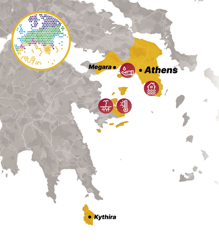
Situation

Attica is a typical Mediterranean region, subject to strong and increasing impacts caused by climate change and other global change drivers and stressed by various factors arising from dense human population and insufficient sustainable management and protection of the natural environment.
 
The region of Attica in Greece has around 3.7 million inhabitants in a 3,8 thousand km² area that includes the capital of Greece, Athens, and the surrounding district. The area has two main rivers, which have been transformed into covered storm water conduits in urban areas and drain into Saronikos Gulf. The east Attica region is mainly based on agriculture activities and in present times is facing rapid urbanisation, altering landscapes and straining water resources. Despite challenges, agriculture persists alongside emerging industries. Inadequate water infrastructure and urban expansion threaten the region’s biodiversity, emphasising the need for balanced development and conservation efforts. A new East Attica Wastewater System (EAWS) offers an opportunity to become a circular economy/climate change resilience hub.

Climate related issues

Drought and heatwaves

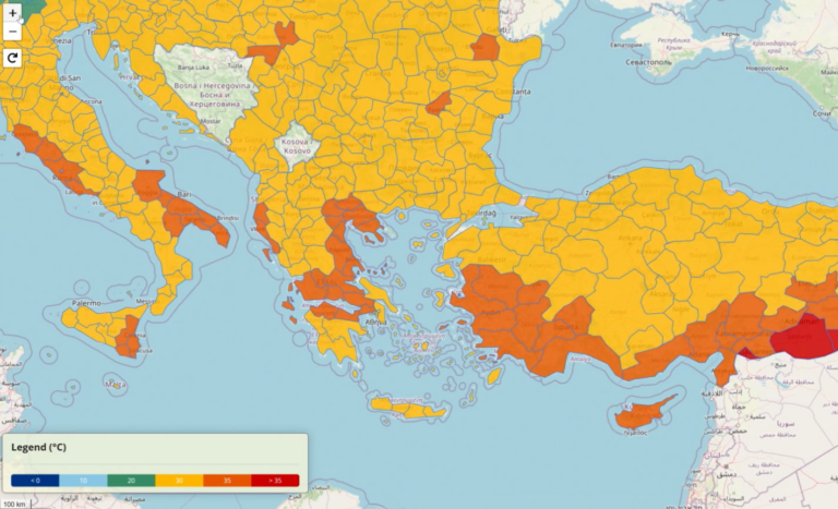
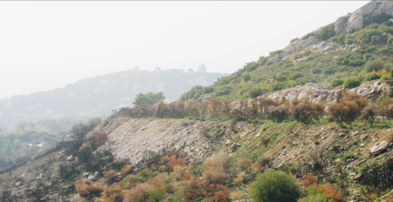
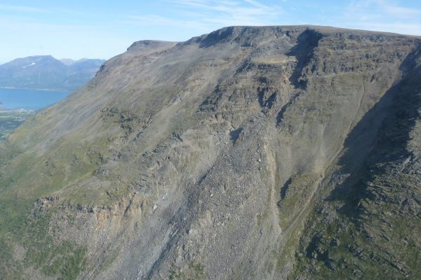
In the Attica region as temperatures rise and rainfall patterns become less predictable, water scarcity and drought is the most urgent climate risk resulting in more frequent and more intense heatwaves.

Water supply and quality

In Attica, due to the impact of climate change, the water supply system may be affected resulting also in water quality deterioration.

Flash flooding

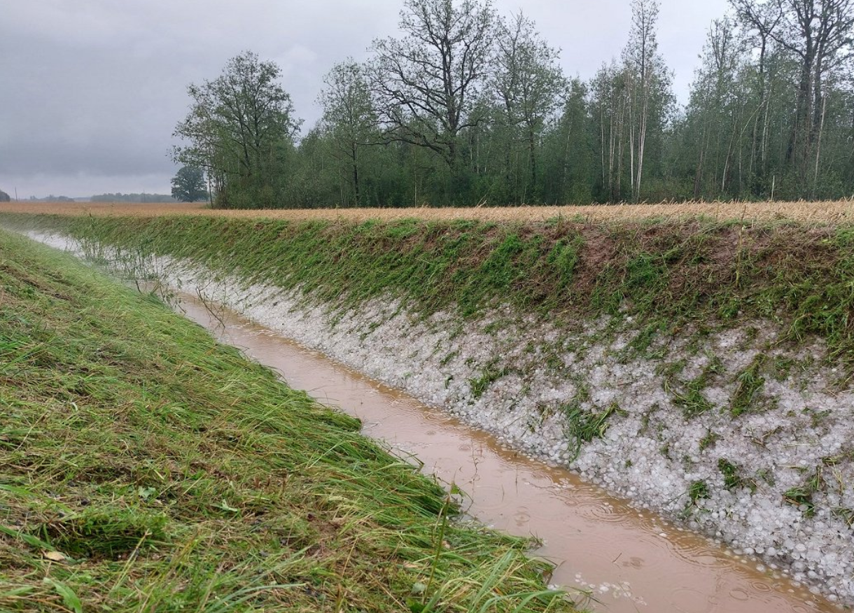
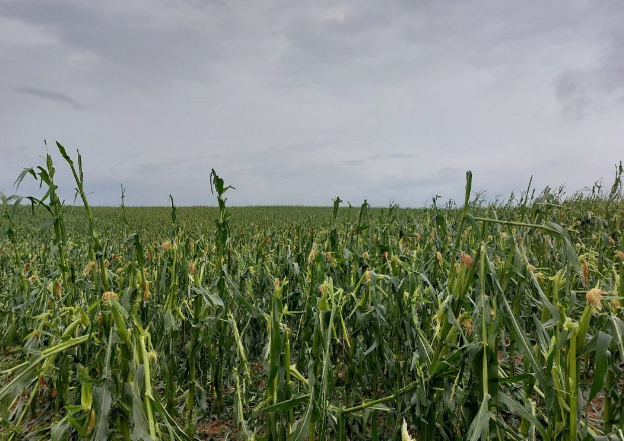
The increase of flash floods in Attica in recent years both in terms of frequency, and in terms of their adverse effects, are probably due to changes in land cover and land use due to construction and urbanization and, of course, climate change.

Key actions

In the Attica Demonstration Site several activites are implemented:

Energy Autonomous Sewer Mining Unit:

  • Constructed in Markopoulo, Attica.
  • Demonstrates converting waste into a resource.
  • Increases the area’s resilience to climate change.

Controlled Environmental Agriculture Solution:

  • Developed in a Greenhouse facility in Spata, Attica.
  • Optimises resource use (water, energy, fertilisers) through a smart tool for facility operators.

Online Biodiversity Monitoring Service:

  • Covers the entire Attica region.
  • Monitors biodiversity continuously.
  • Offers restoration strategies based on existing biodiversity and ecosystem services.

Digital Twin Development:

  • Visualises interventions, tools, and modeling results in real-time.
  • Enhances the maturity of installations.
  • Increases society’s preparedness for climate change impacts.
  • Conducts modelling exercises for wastewater systems, promoting regional circular economy and climate resilience.

Masterplan and Business Plan for Reused Water:

  • Focuses on the Mediterranean demo site.
  • Utilises water extracted from the wastewater of the East Attica integrated wastewater system (central facilities and sewer mining units).

Water-Energy simulation and optimisation model for wastewater systems 

  • Deploy a coupled water-energy simulation and optimisation model in the East Attica wastewater system (EAWWS).
  • Advanced uncertainty-aware optimisation techniques are embedded in the model to allow climate-proofing of the resulting operational rules under deep uncertainty.
  • The model acts as a regional circular economy and climate resilience hub.

Relevant sectors:

Urban

Agricultural

Industrial

Our ambitions

Within IMPETUS, our ambitions are clear:

We aim to scale up the use of research and innovation solutions in systemic ways to trigger the development of agriculture, industry, and tourism, building on existing initiatives. Our goal is to develop regional data-driven platform initiatives to create a digital twin of the region, establishing it as a hub for data and knowledge. We are committed to setting up a regional user-centred Resilience Knowledge Booster (RKB) and linking it with existing innovation and start-up hubs to co-create a regional adaptation pathway.

We strive to bring together local and regional communities of practice, engaging stakeholders in the co-creation and co-ownership of solutions, technological and policy pathways, and portfolios. By implementing and testing selected innovations in key systems and leveraging the EAWS, we aim to create innovation demonstrations throughout the region. We will use immersive storytelling and knowledge networks to enhance open innovation and data-driven policy-making, catalysed by the digital twin and the RKB.

Our efforts pave the way for significant medium-to-longer-term investments committed to supporting the adaptation pathway. We seek to foster large-scale citizen engagement based on diversity and social inclusion, which are key to adaptation and sustainability. We envision the adoption of the IMPETUS adaptation pathway by authorities and the formal engagement of competent authorities in keeping plans up to date. Finally, we aim to facilitate the creation of new ‘green’ businesses around climate change innovations.

Issues

Region-specific solutions

Sewer Mining Technology in Markopoulo, Attica

Sewer mining is an innovative wastewater recycling technology that transforms waste into a valuable resource, thus increasing the availability of water resources where the demand exists and where wastewater is readily available.

Our approach:

The technology offers a flexible, scalable and transferable circular economy solution that can be integrated into a container. The core concept is summarised as follows:

  • Wastewater is extracted directly from the local sewage network.
  • The wastewater is treated on-site at the point of demand.
  • High-quality water is produced mainly for urban green irrigation.

The Sewer Mining system consistently generates approximately 25 m3 of reclaimed water daily. This recycled water is used to irrigate a series of gardens surrounding the technology, yielding excellent results in plant growth, thanks to the nutrients present in the treated water.

The entire process is carefully monitored and controlled through dedicated sensors and actuators, with the system’s performance visually represented via real-time data flow and processing.

Pilot description: Find more information on the Sewer Mining technology installed in Markopoulo in Eastern Attica.

3D model: Navigate in the 3D model of the technology to visualise the units and components.

Real-time data: Explore the data of the parameters that are monitored in the sewer mining unit.

You can visit the Attica Digital Twin Platform here.

Digital Twin, Attica

The Digital Twin of Greece’s Attica Region is a dynamic, virtual representation of real-world applications and water related distributed solutions and geospatial services. The cutting-edge platform leverages real-time data, advanced analytics, and simulation models to mirror the physical system’s behaviour and performance enabling climate adaptation initiatives and solutions and serving as a central hub for knowledge-sharing and action. The platform facilitates a co-creation process that actively engages stakeholders and policymakers to drive green business development and enhance climate resilience.

Our approach:

Attica’s Digital Twin aspires to become a one-stop shop for identifying innovative solutions already implemented across the region. It showcases distributed interventions such as the sewer mining solution that is implemented at Markopoulo Urban Gardens and at the Athens Plant Nursery, as well as applications of Controlled Environmental Agriculture in Spata, aiming at optimising resources efficiency in water, energy and materials. The platform also provides access to geospatial services such as the Reforestation services that offer localized insights based on biodiversity changes and restoration efforts. Additionally, the platform serves as an inventory of innovative solutions and applications. Designed with scalability in mind, the Digital Twin can be easily expanded and adapted to incorporate new data sources, technologies, and evolving system requirements, including integration with third parties’ developments. Its flexibility makes it an indispensable asset for promoting sustainable, data-driven decision-making across the region.

Controlled Environmental Agriculture in Spata, Attica

The Controlled Environmental Agriculture (CEA) solution is a pilot decision support system that enhances resource efficiency (water, energy and fertilisers) in agriculture, boosting the resilience and sustainability of the Attica region and its surrounding habitats.

Our approach:

Serving as a proof of concept, the pilot demonstrates the implementation of innovative, sustainable technologies in greenhouse farming. The platform enables users to set optimal microclimate parameters for their crops, using sensors, actuators, and intelligent networks. Integrated machine learning tools provide tailored recommendations for adjusting equipment to maintain ideal conditions, supporting agronomists in monitoring and correcting environmental factors to ensure sustainable farming practices.

The Attica Green hydroponic facility, located in Spata in eastern Attica, is the test site for this initiative, showcasing eco-friendly, high-quality products from its greenhouses.


Pilot description: Find more information on the Controlled Environmental Agriculture solution installed in Spata in Eastern Attica.

Real-time data: Explore the data of the parameters that are monitored in the selected Greenhouses.

Optimisation of greenhouse operation: Get recommendations for optimal equipment adjustments in windows, curtains and fans to achieve the desired conditions.

Reforestation Service in Attica

The Reforestation Service is an online decision support tool for assessing deforested areas, tracking species and biodiversity changes, and providing localized restoration strategies. It integrates remote sensing, spatial data, machine learning and stakeholder input to monitor deforestation and biodiversity loss, offering tailored guidelines for successful restoration. This service is also integrated in the Attica Region Digital Twin

Our approach:


The Forest Loss & Biodiversity Monitoring module provides seasonal updates on vegetation, deforestation trends, and biodiversity fluctuations. The Restoration Suggestions DSS ensures that reforestation efforts are adapted to local conditions, promoting evidence-based ecological restoration and resilience to climate impacts. This adaptable approach is scalable and transferable to other regions with similar challenges.

You can find the Online Biodiversity Service here.

Attica Master and Business Plan for reused water

The Attica Master and Business Plan presents a comprehensive strategy to address water scarcity, enhance agricultural productivity, and improve local quality of life. Its goal is to reduce dependency on freshwater resources, promote resource efficiency, and contribute to climate change mitigation and regional resilience.

Our approach:

The Master Plan proposes innovative interventions that combine the reuse of treated wastewater from the Eastern Attica Wastewater Treatment Plants (WWTPs) with decentralized water reuse systems. These measures aim to secure water resources while minimizing environmental impacts. By leveraging financial instruments to support sustainable solutions, the project strengthens regional water security and aligns with both EU regulations and the United Nations Sustainable Development Goals (SDGs).

As part of the Regional Master Plan, stakeholder engagement through bilateral meetings and consultations identified key measures to strengthen climate change resilience in Attica. These efforts support long-term feasibility, climate adaptation, and the development of a self-sufficient, climate-resilient region. Notably, a financial mechanism was designed to demonstrate how fiscal instruments can facilitate the implementation of 27 sewer mining units across 21 parks in the Attica region over the next five years. This structured subsidy model ensures long-term viability. The economic assessment confirmed that investing in sewer mining significantly boosts climate resilience while delivering economic, environmental, and social benefits.

Water-Energy simulation and optimisation model for wastewater systems

A coupled energy-water simulation model was developed to assess the future prospects of the East Attica Wastewater System (EAWWS). Serving as a decision-support tool, the model quantifies the system’s resilience and the energy required to provide climate-resilient utilities to interconnected settlements—and, by extension, to the entire region.

Our approach:

Built using the HYDRONOMEAS framework, the model optimizes wastewater treatment and reuse processes to enhance sustainability and resilience. It incorporates climate change scenarios, population growth projections, and a range of wastewater reuse options to support the design of a robust, adaptive system.

East Attica offers a unique setting for implementing this approach, given its population density, industrial activity, and pressing environmental challenges. The region’s settlements are expected to benefit significantly from improved water management practices and the adoption of circular economy principles.

The study placed strong emphasis on integrating climate change considerations, uncertainty analysis, and stakeholder engagement to support robust decision-making and effective implementation. As a result, the EAWWS is positioned to deliver a more reliable, sustainable water supply for East Attica -capable of withstanding the impacts of climate change and increasing water demand.

icon_storm

Extreme events

Reports from European Environment Agency indicate that over the past decades, Europe has been experiencing frequent and severe weather and climate-related natural hazards like droughts, forest fires, heatwaves, storms and heavy rain. Climate change will make these events even more intense and more frequent. The summer of 2024 was the hottest on record for Europe and globally. While up to recently the extreme events were not considered usual in Zemgale region, experience from few previous seasons raise precautions. In summer 2024, there were heaviest rains that Latvia has experienced since 1945.

The impact of various extreme weather events has been particularly pronounced in places with high population density, such as the city of Jelgava. The region’s flat topography and land surface elevation relative to sea level result in high groundwater levels, which place additional stress on the city’s drainage and storm water drainage systems.

Issue

In Jelgava, the main challenges from rainfall include high risk of flooding and damage to infrastructure during prolonged rainfall. The Lielupe River and its tributary floodplains, as well as low topography and high-water tables, make drainage and stormwater drainage systems difficult to operate. The extreme rainfall of July 2024 confirms that the existing sewerage system is inadequate to cope with such situations.  In the region’s rural areas, the threats affect both settlements and villages and fertile agricultural land, which plays an important role in the region’s economy.

Storms are the second most pronounced weather extreme in the region and, although on average winds are not expected to change significantly over the 21st century, by the end of the century (relative to the period 1971-2000) there will be a greater number of both windless days and stormy days per year.  In recent years, the Zemgale region has been severely affected by thunderstorms and storms that have brought heavy rainfall in the form of both rain and hail, destroying agricultural crops and damaging infrastructure in many places. Severe storms in summer and early autumn, when trees and shrubs are still in leaves, have caused severe damage.

Climatologists believe that the current extreme values will become the norm in the future, while extreme weather events will cause even more damage. Climate models also predict an increase in total annual precipitation over the 21st century, with an average annual precipitation in Latvia of 775.7 [±60.0] mm for minor, 806.5 [±72.8] mm for moderate and 814.2 [±79.7] mm for major climate change. Predictions foresee substantial increase in duration of heatwaves from climatic norm of 8 days to 16 [±8] days for minor, 22 [±9] days for moderate and 33 [±12] days for major climate change.

Forecasting extreme weather events is quite complicated task, as these events are characterized by short-term nature, they and spatially limited, and thus short warning times are operational. Measures for adaptation to climate change thus become essential by preparedness for more days with extreme temperatures and for more extreme precipitation events. Decision-makers and local authorities need data and information to make the necessary preparations in advance by adapting to the different scenarios and possible consequences.

Within activities of IMPETUS project, the Adaptation Pathways are elaborated for Zemgale region with particular focus on flooding occurrences from river spring floods and heavy rain events:

  • Adaptation pathways are developed to support in better management of river flood risks and heavy rain floods (flash floods).
  • Aimed to implement a set of measures for reducing the frequency and extent of flooded areas in both rural (agricultural) land and urban settlements.
  • In exchange with the stakeholders, adaptation options are identified, assessed and included in the pathways to increase adaptive capacity in Zemgale region.
  • Structural measures, e.g., upgrading of existing drainage and stormwater drainage systems, and aligning them with nature-based solutions for water retention in rural and urban areas, and cleaning of riverbeds are considered.
  • Non-structural measures for improving flood risk early warning system (EWS), increasing awareness of inhabitants and improving the efficiency of actions of competent authorities in case of floor risks are addressed.
icon_flood

Flooding

Zemgale is a very flat region, located in a lowland area with a high density of rivers. The Lielupe River is characterized by its slow course, due to Zemgale’s flat topography and the low gradient of the riverbed. The height of the Lielupe floodplain does not exceed 1 m above water level. Downstream of Jelgava, the Lielupe River drops only 5-10 cm/km. The riverbed is much lower than the average level of the Baltic Sea.

Issue

Climate change in the Zemgale region by the end of the 21st century will have a major impact on the hydrological regime.  One of the most significant changes will be increased precipitation: under a moderate climate change scenario, winter precipitation will increase by 24-38%, while under a significant climate change scenario, precipitation is expected to increase by as much as 35-51%. Maximum daily precipitation will increase by about 3-6 mm, in some places by as much as 10-12 mm. On a seasonal basis, the greatest increases in precipitation are expected during the winter and spring seasons, so that the risk of flash flooding increases significantly during the cool season, when evapotranspiration is not intense. Periods of high rainfall will alternate with prolonged droughts, which will have a particular impact on heavy rainfall events, increasing the frequency of flash floods. During heavy rainfall, short, localised flooding can be observed in both larger and smaller towns, as well as in flat rural areas.

One of the activities in Zemgale in the IMPETUS project is the improvement of the Flood Early Warning System using the HEC-RAS 2D model. This model simulates water flow in two dimensions, which is particularly useful for flood modelling and forecasting. The HEC-RAS 2D model uses two-dimensional Diffusion Wave Equations to calculate the water flow. The developed model performs 2D

Key Benefits of Using Such a Hydraulic Model

  1. Accuracy and Detail: The HEC-RAS 2D model provides high accuracy and detail, which is essential for flood risk assessment and management.
  2. Integration: The HEC-RAS 2D model can be integrated with other geographic information systems (GIS), facilitating data processing and visualization.
  3. Early Warning Systems: The model is crucial for the development of early warning systems, as it allows for the prediction of flood spread and impact, thereby helping to timely warn residents and take necessary measures.
  4. This solution automatically reads hydrological forecast data from the forecast system of the Latvian Environment, Geology and Meteorology Centre.

These model results are crucial for the operation of the Early Warning System, which uses this data to identify potential flood areas and prepare warnings at the property (cadastral unit) level.

icon_heat

High temperatures

Record-breaking summertime temperatures have been recorded in the Netherlands in recent years. With global temperatures rising, such extreme weather events will occur more often, and for longer periods. Prolonged high temperatures, with warm nights as well as hot days, can cause heat stress* and related health issues, particularly among city populations.

*Heat stress occurs when the human body cannot get rid of excess heat and can impact wellbeing through conditions such as heat stroke, exhaustion, cramps and rashes.

"We want to enable municipality decision makers who are working on spatial developments to identify heat stress 'hot spots' and cool areas, analyse the future effects of climate change, and model the effect of different heat stress-reducing measures. The tool must provide them with an easy starting point to integrate heat stress risks in their projects."

Issue

Despite the cooling effect of the sea in the region of Zeeland, the growing risk of heat stress has become a concern.

Elderly and other vulnerable people are more impacted by the effects of prolonged heat, which can cause headaches, dizziness, insomnia and other health issues – even death. Excess temperatures also affect general comfort and liveability of cities. Water quality can be reduced, both for drinking and swimming, and infrastructure can be affected. Buildings and concrete surfaces trap heat, potentially leading to damage, and release it during the night, keeping temperatures warm.

During heat waves, it is important that everyone has access to a cool and comfortable place. Appropriate spatial planning can help to decrease and deal with heat stress. Environmental factors like water bodies, trees, and shade have a major impact on stress caused by high temperatures. Therefore, planting trees, removing concrete surfaces, creating green roofs and cool spaces can improve our comfort and health. The IMPETUS Atlantic team is developing a digital tool to support regional decision making for city planning to address these needs.

icon_flood

Flood risk

By 2050, sea-level within this region is predicted to rise by 15-40 cm, with more frequent extreme weather and more (severe) storms triggered by climate change. These changes will exacerbate the natural risk of flooding in the IMPETUS ‘Atlantic’ region, because it is surrounded by rivers and the sea, and is below sea level.

*Risk takes into account two aspects; the chance that an event will occur and the negative impact of such an event once it occurs. When there is a low chance that an event will occur, but its impacts are huge, the risk is still significant.

“In the Netherlands, an extensive system of dikes protects us against sea and river flooding. We have always put our faith in this defence and focused almost solely on flood prevention. However, pressure on our system will increase with climate change and rising sea levels. To adapt and maintain a safe living environment, we should develop other safety measures, like more robust spatial planning and contingency plans."

Issue

Rotterdam city, is located in Rijnmond – ‘mouth of the Rhine’. The Rhine river flows through this densely populated area and characterises the region. Protections such as sea dikes and storm surge barriers have been constructed to protect the region, but flooding still occurs.

People living in the city are accustomed to seeing smaller floods. The changing climate affects the interplay between rainfall, river levels and sea storms, increasing the flooding risk. Water levels could rise by a few metres, even in populated areas, with potentially massive impacts. 

Mitigation measures such as storm surge barriers reduce the chance that high water reaches the city, but to minimise the impact of floods when they do occur, adaptation strategies are also needed. A city that can adapt to be safe from floods must be carefully designed. How best to design such an adaptive city?

Critical infrastructure, such as hospitals and evacuation routes, must be accessible at all times. Planning how to best protect them, homes and lives is complex. Flood water behaves in a complex way and flood risks show strong spatial variations. The IMPETUS Atlantic team is developing a digital tool to support regional decision making for adaptive city planning. 

icon_factory

Energy and waste water

To become climate-neutral by 2050, climate mitigation* efforts are crucial in our strategy for how to deal with climate change. Reducing our energy consumption is a significant mitigation step. In the Netherlands, 15% of energy is consumed in the Rijnmond area around the port of Rotterdam, in large part by a major petrochemical industry cluster.

*Climate mitigation encompasses measures such as technologies, processes, or practices that reduce carbon emissions or enhance the sinks of greenhouse gases.

Issue

The Rotterdam port petrochemical industry cluster is Europe’s largest. It consumes 70% of the Rijnmond region’s energy. A large part of this energy is wasted (64%, 203 petajoules). More than half of that energy is lost with wastewater. In addition, most energy processes within these industries rely on fossil fuels, which has a significant impact on the climate.

Energy use must be minimised and fossil fuels should be replaced by renewable sources if climate change is to be mitigated. Electrification of processes opens up the possibility to use more renewable energy and can greatly impact decarbonisation. Recovering wasted heat would significantly reduce energy consumption and is a first step towards a more circular industry. 

Supporting industries in a transition towards climate-neutrality depends on identifying how best to reduce their carbon footprint without sacrificing production or performance. The IMPETUS Atlantic team is creating a digital tool that supports decision making about pathways towards an effective energy transition for EU industry.

icon_fertilizer

Eutrophication

Due to its fertile soils, Zemgale region in Latvia is characterised by an intensive agriculture where large-scale farming dominates. Agricultural activities are well developed and focus on the cultivation of crops.

During the last decade, the area of croplands in the region has increased along with application of high amounts of mineral fertilisers. Excessive loading of nutrients (nitrogen and phosphorus) lead to eutrophication of water bodies e.g., causing overgrowing of rivers, and thus putting a pressure on biodiversity and natural habitats.

Issue

Municipal wastewater effluent is another source of eutrophication in the region. Quite often performance of wastewater treatment facilities is not sufficiently effective to ensure complete purification of waste waters causing water pollution with nutrients. As the result the ecological water quality of the rivers in Zemgale region is mostly moderate or bad.

According to water quality monitoring data of 88 waterbodies located within the Lielupe River basin district, there are 53 waterbodies having significant disperse pollution load and 14 water bodies where point source pollution load prevails (Source: LEGMC, 2024).

Climate change related increase of temperature catalyses eutrophication processes in water bodies. Climate models predict continuation of the increase of temperature thus intensifying the symptoms of eutrophication in freshwaters. Therefore, along with reduction of use of fertilisers, improvement of municipal wastewater treatment facilities, application of additional measures to prevent nutrient runoffs from agricultural land and urban environment to water bodies is of pivotal importance.

Together with regional and local stakeholders in Zemgale region, IMPETUS project partners in Latvia are developing Zemgale regional climate change adaptation plan, that will highlight the possibilities and intention of implementation of nature base solutions, e.g., constructed wetlands in Zemgale region to reduce the nutrient leakages/runoffs, reduce eutrophication intensity and improve the quality of surface waters.